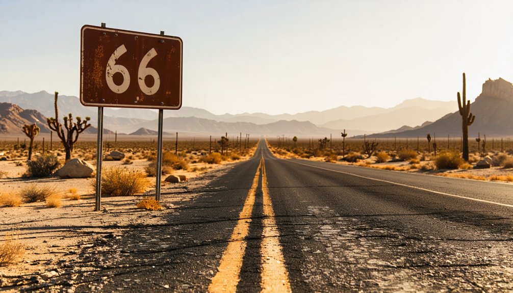
Planning a ghost town road trip to Chambless, California means heading south of Interstate 40 along historic Route 66, roughly ten miles west of Amboy in San Bernardino County’s Mojave Desert. Spring and fall are your best seasons, since summer temperatures regularly top 110°F. You’ll find abandoned gas station ruins, eerie silence, and zero crowds — just raw mid-century highway history frozen in the desert sun. Stick around, and there’s far more to uncover about this forgotten stretch of America’s most iconic road.
Key Takeaways
- Chambless is a Mojave Desert ghost town along historic Route 66, located approximately ten miles west of Amboy in San Bernardino County.
- Visit during spring or fall, as summer temperatures can exceed 110°F, making survival in this remote desert location extremely challenging.
- Access Chambless via Interstate 40, taking the historic Route 66 exit and traveling east approximately ten miles to Cadiz Road junction.
- Avoid post-storm travel, as washed-out bridges create dangerous dirt road detours that can hinder safe access to the area.
- Key nearby landmarks include Road Runner’s Retreat, Amboy Crater, and Route 66 Monument Signage, offering additional stops for road trippers.
What Is Chambless, California?
Chambless is a ghost town in California’s Mojave Desert, sitting south of Interstate 40 along historic Route 66 in San Bernardino County. It’s located ten miles west of Amboy and three miles north of the railroad town of Cadiz, placing it deep in the heart of the open desert.
This slice of desert history began in the early 1920s when James Albert Chambless homesteaded at the crossroads of Cadiz Road and National Trails Road. When that road became Route 66, his small settlement grew into a thriving traveler’s stop.
Today, it stands abandoned, bypassed by Interstate 40 and left to the desert silence.
Visiting Chambless means stepping into a raw, unfiltered piece of American road history — the kind of place that rewards the curious and the free-spirited.
Where Is Chambless on Route 66?
Tucked along a quiet stretch of historic Route 66 in San Bernardino County, Chambless sits south of Interstate 40 in California’s Mojave Desert, roughly ten miles east of Amboy and three miles north of the railroad town of Cadiz. Its remote position makes it a compelling stop for anyone chasing Route 66 nostalgia.
Use these landmarks to orient yourself:
- Interstate 40 runs north of town
- Amboy Crater sits ten miles west
- Cadiz, a railroad town, lies three miles south
- Kelbaker Road leads toward Cadiz Summit for area access
Chambless history unfolds quietly across this desert landscape, where the ZIP code 92319 and area code 760 mark coordinates that once hummed with traveler activity and desert community life.
How a Homestead Became a Route 66 Desert Pit Stop
In the early 1920s, James Albert Chambless, an Arkansas transplant, homesteaded at the crossroads of Cadiz Road and National Trails Road, planting the seeds of what would become a desert landmark.
When that road got rebranded as Route 66, increased traffic turned his modest plot into a thriving pit stop, prompting his family to build a store, gas station, and motel by 1932.
You can trace that evolution today as you pass through what’s left of a community that once kept weary Mojave Desert travelers fueled, fed, and sheltered.
Chambless Family Desert Roots
What started as a humble homestead in the early 1920s eventually became one of Route 66’s most essential desert pit stops.
James Albert Chambless, originally from Arkansas, built something remarkable through sheer Chambless heritage and desert survival instincts. His vision transformed a crossroads into a thriving community.
Here’s how it unfolded:
- Chambless homesteaded at Cadiz Road and National Trails Road in the early 1920s.
- Route 66’s designation renamed National Trails Road, bringing increased traveler traffic.
- The family built a store in the late 1920s to serve passing motorists.
- By 1932, they’d added a gas station, motel, and second store.
You’re looking at a family that didn’t just survive the desert — they made it work for them.
Route 66 Drives Growth
When Route 66 replaced the National Trails Road, the Chambless homestead didn’t just gain a new address — it gained a lifeline to thousands of cross-country travelers who needed exactly what the desert rarely offered: fuel, food, and a place to rest.
The family wasted no time capitalizing on that traffic. They built a store in the late 1920s, then added a gas station, motel, and second store by 1932.
What started as a solitary homestead transformed into a functioning desert community, serving everyone pushing through the Mojave’s relentless heat.
Even a Whiting Brothers station eventually appeared a quarter mile west, confirming that Chambless had become a legitimate Route 66 stop — proof that the right road through the right desert can turn ambition into something real.
From Homestead To Hub
Before Route 66 carved through the Mojave, James Albert Chambless had already staked his claim at the intersection of Cadiz Road and National Trails Road in the early 1920s — a bold but modest homestead in one of America’s most unforgiving landscapes.
This Arkansas transplant’s homestead development unfolded steadily, transforming raw desert into a functioning desert community:
- Early 1920s — Chambless establishes his homestead at the crossroads
- Late 1920s — Family constructs the first store following Route 66 designation
- 1932 — Gas station and motel expand the settlement’s offerings
- Post-1932 — Increased traveler traffic solidifies Chambless as a legitimate desert hub
Each addition answered a real need, turning one man’s claim into a lifeline for road-weary travelers crossing the Mojave.
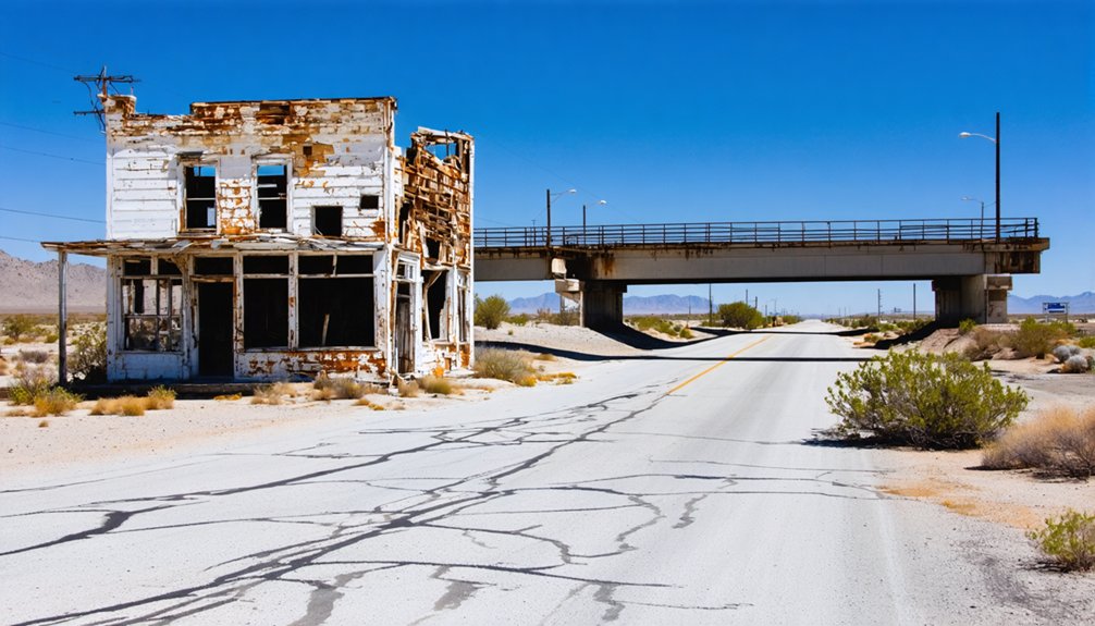
What Killed Chambless: Interstate 40 and the Route 66 Bypasses
When Interstate 40 bypassed Route 66, it pulled the lifeblood right out of Chambless.
Travelers who once stopped for gas, food, and a motel room now flew past on the new highway without a second glance.
With Route 66 traffic gone, the little desert community that James Chambless built from scratch simply couldn’t survive.
Route 66 Traffic Vanishes
The same Route 66 traffic that breathed life into Chambless ultimately signed its death warrant. As interstate highways reshaped American travel, the ghost town allure you feel today emerged from a brutal economic collapse.
Four decisive blows destroyed Chambless:
- Interstate 40 bypassed Route 66 entirely, rerouting cross-country traffic away from the desert corridor.
- Travelers no longer needed remote desert stops when faster, more connected highways emerged.
- Businesses lost customers overnight, making operations financially unsustainable.
- The community’s population dissolved, leaving structures abandoned to desert nostalgia.
You can still trace this trajectory driving through today. The empty buildings and faded signage aren’t accidents — they’re timestamps marking exactly when America stopped needing Chambless.
That abandonment transforms every crumbling wall into a powerful, tangible piece of highway history.
Interstate 40 Bypasses Town
Once Interstate 40 sliced through the Mojave Desert, it didn’t just reroute traffic — it surgically removed Chambless from America’s mental map. The bypass impact was immediate and brutal. Travelers who once needed gas, food, and shelter in Chambless now cruised past at highway speeds, never knowing the town existed.
You have to understand what Route 66 meant to these desert communities — it was their oxygen. When the interstate severed that lifeline, Chambless couldn’t survive. Businesses shuttered, families left, and the desert began reclaiming everything.
Today, you’re visiting a ghost town that didn’t fade gradually — it got erased. The freedom of open-road travel that built Chambless ultimately destroyed it, replaced by an efficiency-obsessed highway system that had no room for small desert stops.
Travelers Stop Coming
Travelers didn’t just stop coming to Chambless — they stopped knowing it existed. Once Route 66 bypasses and Interstate 40 rerouted traffic, the town’s lifeline vanished overnight. That’s the harsh reality of desert isolation — when the road moves, everything dies.
Four events sealed Chambless’ fate:
- Route 66 bypasses redirected cross-country travelers away from the main corridor
- Interstate 40 eliminated stopping points like Chambless entirely
- Fuel and supply needs got absorbed by larger, accessible highway towns
- Desert isolation made revival economically impossible
What remains today fuels your travel nostalgia — crumbling structures, faded signs, and silence so complete it feels deliberate.
You’re not visiting a forgotten town; you’re witnessing exactly what happens when America builds a faster road and never looks back.
When to Visit Chambless and This Stretch of Route 66
Timing your visit to Chambless and this stretch of Route 66 matters more than you might think. The Mojave Desert’s extreme heat makes spring and fall the best seasons for exploring this ghost town stretch.
Summer temperatures regularly exceed 110°F, turning your adventure into a survival situation. Winter visits work too, though cold nights and occasional storms can damage the unpaved detours around broken bridges, making sections impassable.
At 110°F, summer stops being an adventure and starts being a fight for survival.
Avoid driving this area immediately after storms regardless of season, since washed-out dirt bypasses become treacherous quickly. Unlike busier Route 66 towns, Chambless hosts no local events to plan around, so you’re free to visit on your own schedule.
Just prioritize cooler months, check road conditions beforehand, and you’ll experience this desert landmark exactly as it deserves.
How to Get to Chambless From Interstate 40
To reach Chambless, take Interstate 40 to the exit for historic Route 66, which runs south of the freeway through the heart of the Mojave Desert.
Once you’re on Route 66, head east along the iconic highway, following the path that once carried countless travelers through this remote stretch of California.
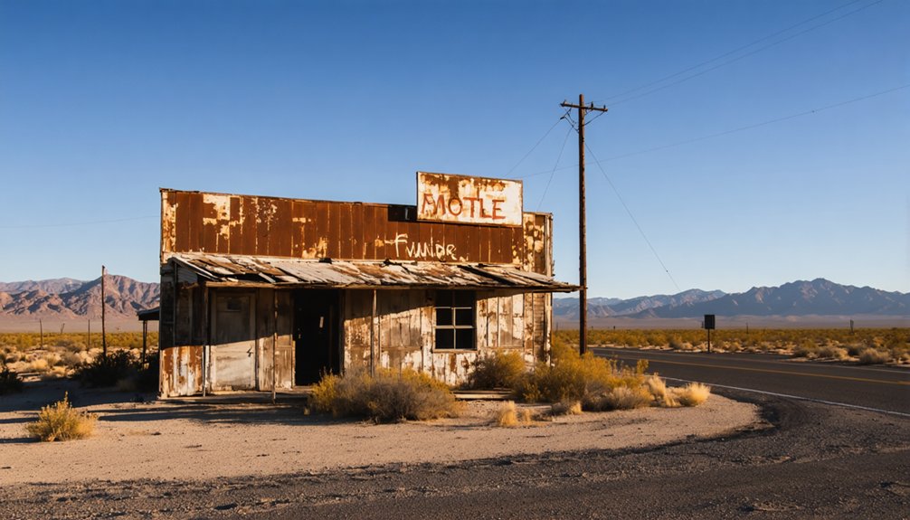
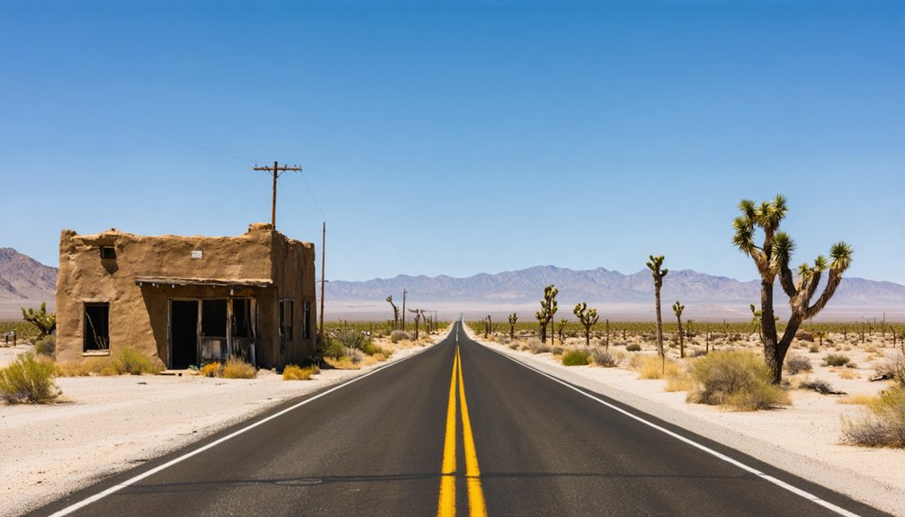
You’ll know you’ve arrived at Chambless when the remnants of the old settlement appear on your right, a weathered snapshot of mid-20th century desert life.
Locating Interstate 40 Exit
Finding the exit for Chambless off Interstate 40 is straightforward once you know what to look for. The historic Route 66 corridor guides you directly into this desert ghost town’s ghost town attractions, where desert wildlife occasionally crosses your path.
Follow these steps:
- Travel east or west on Interstate 40 toward San Bernardino County’s Mojave Desert stretch.
- Watch for the Kelbaker Road exit, your primary access point southward onto historic Route 66.
- Turn south onto Route 66, heading toward Chambless, located roughly ten miles east of Amboy.
- Pass Cadiz Summit before reaching the settlement’s remaining structures.
The ZIP Code 92319 and area code 760 confirm you’re in the right region.
Keep your eyes open—desert wildlife roams freely here.
Once you’ve exited onto Kelbaker Road, three distinct landmarks help orient your drive south along historic Route 66 toward Chambless.
First, you’ll pass the Road Runner’s Retreat, a desert attraction featuring a vintage neon sign that’s impossible to miss.
Continuing south, a 1950s rest area turnout marks the Route 66 Monument Signage near Cadiz Summit, connecting you directly to this highway’s rich route history.
Finally, an abandoned gas station emerges like a mirage on your right, signaling your arrival near Chambless.
Short dirt detours occasionally redirect you around damaged bridges, but most are car-drivable under normal conditions.
Avoid this stretch immediately after storms, as road conditions deteriorate quickly.
Each landmark tells a story, rewarding curious travelers willing to explore this forgotten desert corridor.
Arriving At Chambless
After those desert landmarks guide you through Route 66‘s weathered corridor, you’ll want to know exactly how to reach Chambless from Interstate 40. This ghost town sits south of I-40, waiting to reward travelers who seek authentic desert history.
Follow these four steps to arrive:
- Exit Interstate 40 heading south onto historic Route 66
- Drive east past Amboy, traveling approximately ten miles
- Watch for the junction of Cadiz Road and National Trails Road
- Turn south toward Kelbaker Road, where Chambless unfolds before you
San Bernardino County’s Mojave Desert surrounds this once-thriving community, which carried ZIP Code 92319.
Three miles north of the railroad town Cadiz, Chambless emerges quietly from the landscape, its skeletal remains telling stories that paved roads and bypasses couldn’t completely erase.
What You’ll Actually Find When You Arrive in Chambless
Pulling into Chambless feels like stepping into a freeze-frame of mid-century America that time forgot to finish erasing. This ghost town rewards curious explorers with raw, unfiltered desert landscapes stretching endlessly in every direction.
You’ll spot the skeletal remains of the old gas station first, its faded sign standing like a sun-bleached sentinel on the right side of the road. The Road Runner’s Retreat sits about one-and-a-half miles west, its vintage neon sign still recognizable against the Mojave sky.
Further along, a 1950s rest area turnout marks the Route 66 Monument Signage near Cadiz Summit. What you won’t find are crowds, gift shops, or guardrails between you and genuine solitude. That’s exactly the point.
The Road Runner’s Retreat, Cadiz Summit, and Other Nearby Landmarks
Scattered across this stretch of Route 66, a handful of landmarks give Chambless its particular brand of haunted character.
These roadside attractions reward curious travelers and desert photography enthusiasts equally:
- Road Runner’s Retreat – A neon-signed desert landmark visible 1.5 miles west of the main settlement.
- Route 66 Monument Signage – Located at a 1950s rest area turnout east of Cadiz Summit.
- Old Gas Station Remnants – Appears almost mirage-like on the roadside, a perfect desert photography subject.
- Cadiz Summit – Accessible via Kelbaker Road, serving as your gateway to the monument turnout.
You’ll navigate short dirt detours around damaged bridges, though most are car-drivable.
Just avoid these roads immediately after storms when conditions deteriorate quickly.
Washed-Out Bridges, Closed Stretches, and Road Conditions to Expect
Driving this stretch of Route 66 means accepting a few rough edges.
You’ll encounter short dirt road detours around washed-out bridges, but don’t let that discourage you. Most are car-drivable and easy to navigate under normal conditions.
The real caveat? Avoid this stretch right after storms, when those detours can turn unpredictable and potentially impassable.
The closed sections past Kelbaker Road don’t offer much scenery, so you won’t feel like you’re missing out by skipping deep exploration.
Stick to the recommended route — travel Kelbaker to Cadiz Summit, swing by the monument turnout, then head back west.
You’ll get the experience without unnecessary risk.
Respect the road’s conditions, and it’ll reward you with an authentic, unfiltered slice of Mojave Desert history.
Other Route 66 Stops Worth Making Near Chambless
Once you’ve soaked in Chambless, the road ahead still has plenty to offer.
These desert landmarks keep the ghost town history alive across the surrounding stretch of Route 66:
- Road Runner’s Retreat – A neon-signed icon sitting one-and-a-half miles west, instantly recognizable from the highway.
- Amboy Crater – Ten miles west, this volcanic crater delivers raw Mojave drama worth the detour.
- Route 66 Monument Signage – A 1950s rest area turnout east of Cadiz Summit preserves authentic roadside character.
- Goffs Road – Head northeast from Chambless to reach your Day One road trip endpoint with additional stops en route.
Each location adds depth to your desert adventure without doubling back unnecessarily.
Frequently Asked Questions
Is There Cell Phone Service Available in Chambless, California?
Don’t count on cell service reliability in Chambless—it’s a remote Mojave Desert ghost town where local network providers offer little to no coverage. You’ll want to download offline maps and embrace the freedom of disconnecting completely!
Are There Any Camping Spots Near Chambless Along Route 66?
Chambless is your open road to freedom! You’ll find primitive camping near Route 66’s historical sites. Pack your camping gear, embrace local wildlife, and sleep under vast desert skies—nature’s your tent here!
Can You Visit Chambless Year-Round, or Are Some Seasons Better?
You can visit Chambless year-round, but the best seasons are fall and spring when weather conditions are mild. Summer’s brutal desert heat can be dangerous, and storms may damage roads, so plan accordingly!
Is Chambless Accessible to Visitors With Disabilities or Mobility Issues?
Chambless stretches across 10 rugged desert miles, making wheelchair access challenging. You’ll find no accessibility features here — unpaved roads, damaged bridges, and harsh terrain create real obstacles, so plan accordingly before your visit.
Are Pets Allowed When Exploring the Chambless Ghost Town Area?
There’s no official pet friendly policies restricting animals at Chambless, so you’re free to bring your furry companions! Just follow basic ghost town etiquette—keep pets leashed, respect the terrain, and pack out all waste.
References
- https://www.exploratography.com/blog-66/chambless-cal-rt-66
- https://www.theroute-66.com/chambless.html
- http://cali49.com/mojave/2014/11/20/rt-66-chambless
- https://digging-history.com/2014/01/22/off-the-map-ghost-towns-of-the-mother-road-chambless-california/
- https://www.americanwesttravel.com/california/historic-route-66/california-mojave-desert/2/
- https://en.wikipedia.org/wiki/Chambless
- http://patricktillett.blogspot.com/2013/06/chambless-california-route-66-ghost-town.html
- https://www.thedesertway.com/roadrunners-retreat/
- https://www.exploratography.com/blog-66/tag/Ghost+Town


