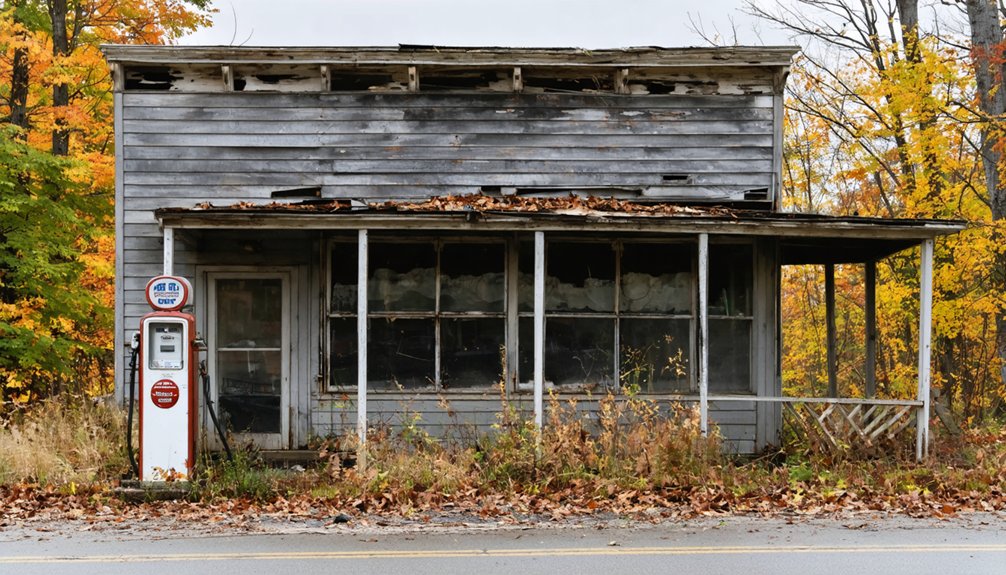
Planning a ghost town road trip to Grove, Vermont means venturing deep into Bennington County’s remote wilderness, where iron ore smelting once fueled a thriving community. Today, you’ll find crumbling cellar holes, ancient stone walls, and the haunting Waters Hill Cemetery tucked beneath dense forest. Start on Route 9 and bring offline maps, sturdy boots, and a compass. Visit in early fall for the best trail conditions. There’s far more to uncover about this forgotten settlement.
Key Takeaways
- Grove, Vermont, located in Bennington County, is accessible via Route 9, with smaller forest service roads leading into the remote wilderness.
- Notable remnants include cellar holes, stone walls, ironworks ruins, ancient apple trees, and Waters Hill Cemetery with graves dating from 1794 to 1861.
- The best time to visit is late summer through early fall, when trails are accessible and foliage displays brilliant colors.
- Essential gear includes waterproof boots, a topographic map, compass, layered clothing, and a headlamp, as conditions can be remote and disorienting.
- Wildlife encounters, overgrown paths, and unmarked hazards require caution; carry extra water, a first aid kit, and inform someone of your route.
Why Grove, Vermont Was Abandoned
Grove, Vermont shares a familiar story with many of the Green Mountain State’s forgotten settlements — prosperity followed by swift, inevitable decline.
Grove’s history traces back to industries that couldn’t withstand changing times. Iron ore smelting once drove the local economy, but when that industry collapsed, the community lost its foundation. Logging and farming followed similar patterns, fading as markets shifted and better roads redirected traffic away from the ridge.
Iron ore smelting built Grove. Logging and farming sustained it. Shifting markets and rerouted roads quietly erased it.
Understanding Grove’s abandonment reasons helps you appreciate what you’ll encounter on the trail. Stone walls emerge from the forest where sheep once grazed cleared hillsides.
Cellar holes mark where families built lives before moving on. Nature reclaimed everything swiftly and completely. You’re fundamentally walking through a living timeline of Vermont’s economic and social transformation.
What’s Left of Grove, Vermont Today
When you arrive at Grove today, you’ll find nature has nearly swallowed every trace of the settlement whole.
Crumbling ruins and overgrown cellar holes are scattered throughout the dense forest, quietly marking where homes and buildings once stood.
Push past the encroaching brush, and you’re walking through what’s left of a community that time simply erased.
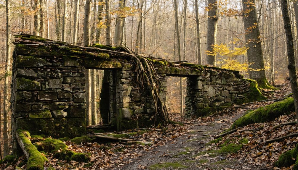
Ruins Still Standing Today
Though the forest has long reclaimed Grove, Vermont, remnants of its past still peek through the undergrowth for those willing to search. This abandoned architecture carries real historical significance, connecting you directly to lives lived centuries ago.
Keep your eyes open for:
- Cellar holes — stone-lined depressions marking where homes once stood
- Stone walls — boundary lines farmers built when clearing land for sheep
- Furnace Grove remnants — scattered ironworks infrastructure from the smelting era
- Waters Hill Cemetery — at least 35 graves dated between 1794 and 1861, bearing surnames like Bickford, Cotton, and Taft
You don’t need a guide to find these features — just sturdy boots, a trail map, and genuine curiosity about Vermont’s forgotten corners.
Overgrown Cellar Holes Remain
What remains of Grove, Vermont today are scattered cellar holes — stone-lined depressions in the earth where families once cooked meals, raised children, and weathered long New England winters.
The forest has swallowed nearly everything else, leaving only these quiet impressions beneath decades of moss, roots, and fallen leaves.
As you walk the old ridge trail from Route 9, you’ll notice stone walls emerging from the undergrowth — boundaries that once defined sheep pastures when this hillside hummed with daily life.
These forgotten lives exist now only in overgrown history, readable if you know what you’re looking for.
Crouch beside a cellar hole and consider what stood above it.
No historical marker explains it. The wilderness reclaimed this place entirely, and that rawness is exactly what makes it worth finding.
Reclaimed By Dense Forest
Those cellar holes don’t stand alone — the forest pressing in around them tells its own story. Dense second-growth woods have swallowed what was once cleared farmland, leaving you to navigate a landscape that hides its past beneath layers of moss, roots, and shadow.
Grove’s forest mysteries run deep here, where ghostly legends still circulate among hikers bold enough to explore.
Watch for these signs of the reclaimed settlement:
- Stone walls disappearing into tree trunks
- Unnatural ground depressions marking former structures
- Ancient apple trees — remnants of homestead orchards
- Unnervingly straight lines of trees following old fence rows
You’re fundamentally reading a buried map. The forest doesn’t erase history — it encrypts it, rewarding sharp-eyed explorers willing to look closely.
What to Expect on Grove’s Trails
Hiking Grove’s trails means stepping into a landscape where nature has slowly reclaimed what humans once built.
You’ll navigate overgrown paths where cellar holes hide beneath leaf litter and stone walls emerge unexpectedly through dense undergrowth.
Trail safety is essential here — uneven terrain and unmarked hazards demand sturdy boots and careful footing.
Wildlife encounters are common, so carry bear spray and stay alert.
Deer, wild turkey, and black bears roam freely through these woods.
You’ll want a detailed topographic map since signage is minimal and trails can disappear entirely.
Bring extra water, a first aid kit, and tell someone your planned route before heading out.
The reward for your preparation is an eerily beautiful, deeply quiet landscape that few people ever experience.
How to Get to Grove, Vermont

Grove, Vermont sits tucked into the mountainous terrain of Bennington County, making it one of those destinations you won’t stumble upon by accident.
You’ll want to take Route 9, the closest major road, as your primary anchor point before steering through the rugged local roads that wind toward the site.
If you’re driving from Bennington, head east on Route 9 and watch for the trailhead markers that’ll guide you into the wilderness where Grove’s remnants still linger.
Grove’s Geographic Location
Tucked away in Bennington County, Grove sits roughly 15 miles northeast of Bennington itself, deep within the Green Mountain wilderness that helped seal its fate as a ghost town. Vermont topography shapes everything here — dense forests, steep ridges, and isolated hollows that once swallowed entire communities whole.
Understanding Grove geography helps you appreciate why abandonment was inevitable.
Use these landmarks to orient yourself:
- Route 9 — Your primary access corridor running east through Bennington County
- Green Mountain National Forest — Surrounds the area, dominating the landscape
- Woodford — The nearest recognizable settlement to reference
- Bennington — Your best resupply point before venturing deeper
You’re entering terrain that doesn’t forgive poor planning, so study your maps before you leave pavement behind.
Nearest Major Roads
Reaching Grove means traversing a handful of key roads that cut through Bennington County’s rugged interior.
Route 9, the Molly Stark Byway, serves as your primary artery, connecting Bennington to Brattleboro through dense forest and rolling terrain. From there, smaller county roads branch northward into increasingly remote wilderness.
You’ll want a reliable vehicle because pavement gives way to gravel quickly once you’re off the main corridor. GPS signals can falter here, so download offline maps before departing.
The isolation you’ll encounter mirrors the same remoteness that shaped Grove history and contributed to the region’s eventual abandonment.
That wild, untamed landscape feeds directly into ghost town legends surrounding this area.
Embrace the freedom of traversing roads few travelers bother to explore.
Recommended Travel Routes
Whether you’re coming from Albany, New York or Burlington, Vermont, Route 9 is your gateway into this forgotten corner of Bennington County. These scenic routes reward explorers who value open roads and raw history.
Travel tips for reaching Grove:
- From Albany, take I-787 North to US-9 East through Bennington — approximately 60 miles.
- From Burlington, follow VT-9 West through Brattleboro, cutting across Vermont’s southern spine.
- From Brattleboro, head west on VT-9 directly into Bennington County’s mountainous terrain.
- From Manchester, Vermont, take VT-11 West connecting to VT-9 South near Bennington.
Once on Route 9, watch for unmarked forest service roads heading into the wilderness. Your GPS may lose signal, so download offline maps before departing.
The Best Time of Year to Visit Grove

When should you plan your visit to Grove, Vermont? Late summer through early fall offers the best experience. The trails are accessible, the foliage transforms the mountainside into brilliant color, and seasonal activities like hiking reveal crumbling cellar holes and forgotten stone walls at their most dramatic.
You’ll feel the weight of history beneath every step.
Avoid winter months — the remote terrain becomes dangerously isolated, and heavy snowfall buries the ruins entirely.
Spring brings muddy, unstable trails that make exploration frustrating.
If local folklore fascinates you, visit during October when the surrounding Bennington Triangle region draws curious travelers enthusiastic to connect with the area’s mysterious disappearance stories.
The crisp air, dramatic landscape, and haunted reputation combine to create an unforgettable, atmospheric experience worth every mile of the journey.
What to Pack for a Vermont Ghost Town Visit
Packing smart can make the difference between a rewarding exploration and a miserable retreat. Grove’s dense wilderness and crumbling ruins demand preparation, not improvisation.
Essential hiking gear and ghost stories aside, your pack should include:
- Sturdy waterproof boots — uneven cellar holes and wet terrain will punish anything less.
- Topographic map and compass — cell service disappears fast in Bennington County’s backcountry.
- Layered clothing — mountain temperatures shift dramatically, especially near Glastenbury’s elevation.
- Headlamp with extra batteries — daylight fades quickly under thick forest canopy.
You’re venturing into genuinely remote territory where abandoned communities and vast wilderness create disorienting conditions.
Pack like someone who respects the land, and you’ll leave on your own terms.
Somerset, Woodford, and Other Ghost Towns Near Grove
Grove doesn’t stand alone in Vermont’s graveyard of forgotten settlements — Glastenbury and Somerset were disincorporated together in 1937, and the surrounding Bennington County backcountry holds enough ruins to fill a week of exploration.
Somerset history traces a similar arc of boom and quiet abandonment, while Woodford legends draw you up mountainside trails where stone walls reveal cleared sheep pastures and cellar holes swallow the forest floor.
The Woodford settlement collapsed after iron ore smelting died and a new road bypassed the ridge entirely.
For ghost town explorations that double as hiking adventures, Waters Hill Cemetery rewards the determined traveler — over 35 graves dating to 1794 rest beneath overgrowth.
Pack your compass, study your maps, and move freely through Vermont’s vast, beautifully forsaken backcountry.
Frequently Asked Questions
Are There Any Paranormal Tours Available in the Bennington Triangle Area?
You’ll find paranormal tours exploring the Bennington Triangle’s haunted legends and ghost sightings in the area. Independent guides often lead adventurous souls through Glastenbury’s mysterious wilderness, where unexplained disappearances and abandoned ghost towns fuel your darkest imaginations.
Can You Camp Overnight Near the Glastenbury Ghost Town Wilderness?
Under freedom’s open sky, you can camp near Glastenbury’s haunted wilderness! Check Green Mountain National Forest’s camping regulations first. The ghost town history whispers through ancient trees as you’re immersed in Vermont’s untamed, mysterious backcountry.
What Surnames Are Found in the Waters Hill Cemetery Near Woodford?
You’ll discover cemetery history rich with notable graves bearing surnames like Bickford, Cotton, Eddy, Harris, Knapp, Lyon, Taft, Temple, and Wood — fascinating families whose stories stretch from 1794 to 1861 in Woodford’s overgrown wilderness.
Did Any Disappearances in the Area Lead to New Law Enforcement Formations?
One of the unsolved cases from the Bennington Triangle’s mysterious disappearances directly triggered law enforcement changes — you’d be fascinated knowing it actually spurred the formation of Vermont’s entire State Police force.
Was South Glastenbury Ever a Tourist Destination Before Its Abandonment?
Yes, you’d be surprised! South Glastenbury’s history includes a brief tourism impact — it once boasted a hotel and casino, drawing summer visitors. Sadly, devastating 1898 floods destroyed the railroad, ending its resort dreams forever.
References
- https://happyvermont.com/2014/10/23/glastenbury-ghost-town/
- https://ournewenglandlegends.com/the-mystery-of-glastenbury-mountain-vermont/
- https://vermontcountry.com/2022/09/18/ghost-town/
- https://www.thelandgrove.com/history-of-the-landgrove
- https://www.youtube.com/watch?v=2fvPo9iQC-w
- https://en.wikipedia.org/wiki/List_of_ghost_towns_in_Vermont


