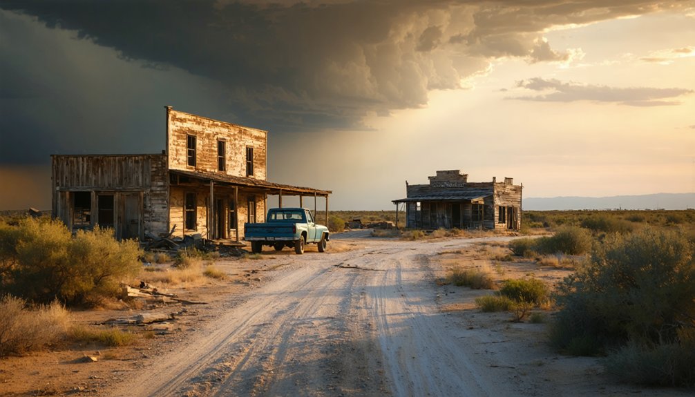
You’ll find Illinois Bend 20 miles northeast of Montague via Farm to Market Road 677, where forty residents occupy windswept prairie that once sustained 300 pioneers. Visit during fall or spring to avoid scorching 95°F summer heat, and cross the historic 1927 Saint Jo bridge spanning the Red River. No original 1860s structures remain—Comanche raids and the devastating 1891 flood erased the gristmills and cotton gins that defined this settlement’s peak. Your journey through scattered homesteads reveals a community shaped by resilient descendants facing ongoing drought.
Key Takeaways
- Located 20 miles northeast of Montague, Texas, accessed via Farm to Market Road 677 and the 1927 Saint Jo bridge.
- Visit during fall (October-November) or spring (April-early May) to avoid summer’s 95.4°F heat and winter’s occasional snow.
- Expect no historical structures remaining; only forty residents occupy scattered homesteads on windswept land today.
- Watch for seasonal flooding in low-lying areas, oil field traffic, and lingering tornado debris from 2013.
- Founded in 1862, the settlement declined after Indian raids, bypassed railroads, and devastating floods erased its infrastructure.
The Rise and Fall of a Texas Settlement
The windswept plains of Montague County hold the fading memories of Illinois Bend, a settlement born from the determination of Illinois pioneers who arrived in 1862. You’ll find this ghost town 20 miles northwest of Montague via F.M. Road 677, where frontier hardships shaped every chapter of its story.
Comanche and Kiowa raids tested the settlers’ resolve, limiting the county’s population to just 890 by 1870. The community initially took the name Wardville after landowner C.M. Ward before residents successfully petitioned for a post office in 1877, at which point they renamed it Illinois Bend to honor their home state.
By 1885, the settlement had grown to include 300 residents, two gristmills, numerous cotton gins, and several churches, marking its peak as a thriving agricultural community.
Getting There: Routes and Road Conditions
Reaching Illinois Bend requires traversing Farm to Market Road 677, a rural ribbon of asphalt that cuts through Montague County’s open grasslands 20 miles northeast of the town of Montague. This backcountry route delivers you to coordinates 33.88167°N, 97.48722°W, where the ghost town slumbers at 722 feet elevation.
Your journey includes these road challenges:
- Red River crossing via the 1927 Saint Jo bridge connects Texas to Oklahoma
- Seasonal flooding concerns threaten low-lying sections during heavy rains
- Tornado-damaged areas from 2013’s EF0 twister left lingering debris
- Oil field traffic near secondary roads adds industrial vehicles
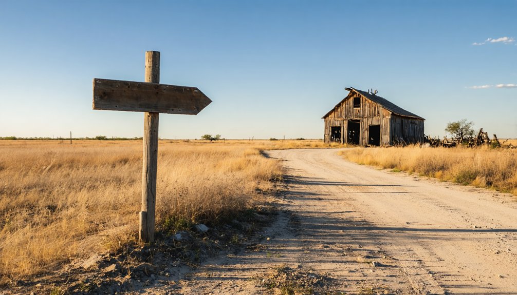
FM 677 remains your lifeline through this untamed territory. There’s no interstate convenience here—just honest gravel, weather-beaten pavement, and the occasional detour around washed-out sections that remind you why freedom tastes sweeter off the grid. The historic bridge, built by Austin Bridge Co., once featured a 700-foot suspended span before its removal. As you navigate the extreme northeastern corner of Montague County, you’ll find yourself in territory that’s been isolated since rail lines bypassed the area over a century ago.
What You’ll Find in Illinois Bend Today
When you arrive at Illinois Bend today, forty hardy souls occupy this windswept corner of Montague County—a skeletal remnant of the 300 residents who once animated these grasslands in 1885. The present day community dynamics reflect rugged independence rather than ghost town desolation.
You’ll navigate Farm to Market Road 677 through scattered homesteads where descendants of original settlers still work the land their ancestors defended against Comanche raids. Don’t expect remaining historical structures from the 1860s—Indian attacks and time claimed those relics long ago. What endures is the spirit of self-reliance.
The gristmills and cotton gins vanished when railroads bypassed this isolated settlement, but the families who stayed embrace that remoteness. The ongoing drought conditions have forced local ranchers to haul water and purchase supplemental feed, challenges familiar to those who’ve weathered this unforgiving landscape for generations. The air quality today registers at 31, which is considered fair for outdoor activities. This isn’t preserved history; it’s living freedom, twenty miles from anywhere that matters.
Best Time to Visit and Weather Considerations
Timing your expedition to Illinois Bend demands respect for Montague County’s unforgiving climate extremes—where January mornings dip to 39.9°F and August afternoons blaze toward 95.4°F across these exposed grasslands.
Illinois Bend’s weather shows no mercy—freezing January dawns and scorching August heat rule these wild grasslands with absolute authority.
Optimal visiting windows:
- Fall exploration (October-November) offers comfortable temperatures and minimal rainfall, with November bringing just 0.91 inches of precipitation
- Spring adventures (April-early May) provide wildflower-dotted prairies, though you’ll face May’s 2.64 inches of rain and potential tornado activity. The region’s highest humidity levels peak in May at 69%, adding muggy conditions to spring storms.
- Summer heat impacts necessitate dawn departures—August’s 95.4°F highs and relentless sunshine make afternoon ghost town photography brutal. North-south winds are common in this part of Texas, bringing moisture off the Gulf of Mexico during warmer months.
- Winter precipitation patterns bring occasional snowfall, particularly February’s 0.28 inches, transforming abandoned structures into haunting frozen tableaus
Your freedom-seeking spirit thrives best during shoulder seasons when weather extremes won’t derail your backcountry explorations.
Historic Disasters That Shaped the Community
Blood-soaked prairie grass marked Illinois Bend’s violent birth in 1863, when Comanche and Kiowa warriors swept down from the Leased Lands across the Red River, obliterating the two-year-old settlement the Illinois emigrants had optimistically named Wardville. The Comanches’ arrival in the region during the previous century had fundamentally altered the balance of power, leading to intensified conflict with the Apaches and devastating raids on settlements like this one.
You’ll find the environmental challenges didn’t end there. June 1891 brought forty-foot floodwaters—ten feet beyond any recorded surge—drowning residents and sweeping away crops, cattle, and entire homesteads before families could flee. Captain J.P. Harris alone lost 400 cattle and 60 horses. The Santa Fe railroad bridge approach on the Indian Territory side was washed away, attracting thousands of spectators who came to witness the treacherous river in its mad flight.
Nature kept hammering this stubborn community through tornadoes in 1955 and 2013, contributing to population decline that eventually reduced Illinois Bend to 68 souls by the late 1940s. Each disaster carved deeper scars into this ghost town’s already troubled landscape.
Combining Illinois Bend With Other North Texas Ghost Towns
Despite centuries of calamity trying to erase it from Texas maps, Illinois Bend anchors one of North Texas’s most rewarding ghost town circuits—a 300-mile round trip from Dallas that strings together four abandoned settlements like faded pearls along dusty FM roads.
Four ghost towns connected by 300 miles of gravel roads—where failed railroads and forgotten dreams built North Texas’s most haunting circuit.
Your route traces the railroad connections that never came and economic factors that sealed these towns’ fates:
- Launch from Krum north to Marysville, where FM 677 cuts through golden grasslands
- Continue to Illinois Bend’s weathered church and rusted gas station
- Push deeper into Montague County through Orr’s scattered remnants
- Cap your adventure at Spanish Fort before looping back through Nocona’s oil fields
You’ll navigate 80% gravel roads passable by any 2WD vehicle, threading through territory once bloodied by Comanche raids, now surrendered to mesquite and memory.
Educational Resources and Historical Background

You’ll find Illinois Bend‘s story preserved in county archives and online historical databases that map its evolution from an 1862 Illinois settlement called Wardville to its 1877 rechristening.
Digital resources reveal how this remote corner of northeastern Montague County, perched twenty miles northwest of town along FM 677, once thrived with 300 souls, gristmills, and cotton gins before the railroads sealed its fate. These tools let you trace the settlement’s timeline against a backdrop of Comanche raids and Red River floods that shaped pioneer life on Texas’s wild northern frontier.
Digital Maps and Guides
Finding Illinois Bend requires more than a casual glance at modern GPS—this remote ghost town sits at precise coordinates 33° 52′ 54″ N, 97° 29′ 14″ W in the extreme northeastern corner of Montague County, where Farm Road 677 cuts through rolling prairie twenty miles from the county seat.
Several digital archives and historical atlases make planning your expedition straightforward:
- Garmin Adventures provides downloadable GPX files tracking 300 miles of 80% gravel roads from Dallas through Krum
- Mapcarta pinpoints latitude 33.88179° N, longitude -97.48705° W with topographic overlays
- Texas Escapes maps highlight FM 677 as your primary access corridor
- Two Wheeled Texans forum shares rider-tested routes with photos and waypoints
These tools transform uncertainty into adventure, letting you navigate confidently toward this vanishing settlement where pavement surrenders to prairie.
Settlement Origins and Timeline
When homesick Illinois pioneers staked their claims along the Red River’s southern bend in 1862, they christened their new settlement Wardville—a tribute to landowner C. M. Ward. You’ll find this frontier outpost twenty miles northwest of Montague, where initial settlement patterns clustered along Illinois Bend’s protective curves.
By 1877, those homesick settlers renamed their community, finally honoring their heartland roots when the post office arrived.
Your ancestors who ventured here faced genuine danger—Comanche and Kiowa raids from the Leased Lands threatened daily existence throughout the 1860s and early 1870s. Only after these raids subsided mid-decade could the town truly flourish.
Nearby Points of Interest Along the Red River
As you follow the Red River’s winding path northward from Illinois Bend, the ghost of Spanish Fort beckons from its perch near the Oklahoma border, where ancient crossing points once funneled settlers and traders between Texas and the Chickasaw Nation.
The river itself tells stories through its landscape—that devastating 1891 flood that rose forty feet still echoes in the carved banks and reshaped bottomlands you’ll pass.
You’re traveling through a corridor where three distinct worlds collided: Anglo settlements pushing north, tribal territories defending their claims, and the unpredictable Red River mediating between them with seasonal fury.
Spanish Fort Historic Site
- French muskets repelled several hundred Spanish soldiers
- Defenders abandoned two Spanish cannons in the moat
- The flying French flag marked allied resistance
- Wooden entrenchments stopped northern expansion
Despite its name, no Spanish garrison ever occupied this ground. Anglo settlers misread the ruins in 1859, cementing a historical irony into local geography.
Red River Crossing Points
The Red River’s muddy current carved more than a border between Texas and Oklahoma—it created a gauntlet that shaped fortunes, tested engineering, and claimed lives throughout the 19th and early 20th centuries.
You’ll discover why cattlemen chose specific fords where nature cooperated with commerce. Red River Station witnessed 60,000 head of cattle jamming up for ten days during flooding—early cattle crossing challenges that defined the Chisholm Trail era from 1867-1887.
River depth fluctuations turned predictable routes into death traps overnight, with the channel spreading nearly a mile wide during extreme floods. Today’s suspension bridges at Illinois Bend (1927), Bryan-Fannin (1927), and Idabel-Clarksville (1929) replaced those treacherous fords, testimony to settlers who refused to let geography dictate their destiny.
Chickasaw Nation Border Area
This disputed territory shaped a complex economic landscape:
Illegal squatters peddled liquor and livestock north of the vegetation line
Benjamin Colbert’s ferry connected Chickasaw commerce between modern-day Colbert, Oklahoma and Denison, Texas
The Chickasaw government strategically leased grazing lands to settlers, controlling expansion on their terms
Chisholm Trail drovers crossed at Red River Station, sustaining trading posts like Fleetwood Store
You’re standing where territorial sovereignty clashed with westward ambition—a boundary defended not just by treaties, but by those who refused subjugation.
Frequently Asked Questions
Are There Any Facilities Like Restrooms or Gas Stations Near Illinois Bend?
You’ll find limited facilities near Illinois Bend, so plan ahead. Big Bend Ranch State Park offers restrooms and parking nearby. Check road condition updates before departing, and pack plenty of drinking water—availability becomes scarce in this remote, untamed frontier landscape.
Is Permission Required to Photograph or Explore the Remaining Structures?
You’ll find freedom meets responsibility here. While no explicit permissions exist, private property concerns and trespassing risks demand respect. Always seek landowner consent before exploring Illinois Bend’s weathered structures—your adventure shouldn’t compromise others’ rights.
What Cell Phone Coverage Can Visitors Expect in This Remote Area?
You’ll encounter significant signal strength variations and data connectivity issues in Illinois Bend’s isolated terrain. Download offline maps beforehand—cellular coverage remains spotty across this forgotten landscape, where freedom means embracing disconnection from the digital world.
Are There Camping or Overnight Accommodation Options Near Illinois Bend?
You’ll find nearby campgrounds at Big Bend National Park and Big Bend Ranch State Park, offering primitive sites and seasonal lodging options. These remote outposts provide starlit freedom under vast Texas skies, perfect for your ghost town adventure.
Is the Abandoned Pink Farmhouse Safe to Approach or Enter?
No, you shouldn’t enter—the pink farmhouse beckons with adventure, but collapsed floors, termite damage, and unstable surfaces create serious potential hazards. The unsecured structures harbor wildlife, legal risks, and unpredictable owners. Your freedom isn’t worth the danger here.
References
- https://www.ghosttowns.com/states/tx/illinoisbend.html
- https://en.wikipedia.org/wiki/Illinois_Bend
- https://www.twtex.com/forums/threads/north-texas-ghost-towns.113876/
- https://historicalbytes.wordpress.com/tag/red-river/
- https://www.aol.com/articles/10-ghost-towns-texas-still-203154544.html
- https://www.atlasobscura.com/things-to-do/texas/abandoned
- https://www.vanishingtexas.net/abandoned-pink-farm-house-near-st-jo-texas/
- https://texashighways.com/culture/history/the-lost-underwater-towns-of-texas/
- https://genealogytrails.com/tex/prairieslakes/montague/
- https://www.bridgemeister.com/bridge.php?bid=601


