Roscoe, Nebraska sits just 7 miles east of Ogallala on Highway 30, and it’s a ghost town that rewards the curious traveler. With roughly 62 residents, crumbling storefronts, and a historic South Platte River bridge, it’s a raw slice of Oregon Trail history frozen in time. Plan for a 30-to-45-minute visit, and pair it with nearby ghost towns like Lowell and Lisco for a full road trip. There’s far more to this forgotten stretch than first meets the eye.
Key Takeaways
- Roscoe, Nebraska sits along US Highway 30 in Keith County, just 7 miles east of Ogallala, making it easily accessible via standard 2WD vehicles.
- The town’s 5-block footprint can be explored in 30–45 minutes, with deeper exploration taking up to 2 hours.
- Abandoned storefronts, weathered signage, and a historic South Platte River bridge offer excellent photography opportunities, especially during golden hour.
- Spring and Fall offer the best visiting conditions, with mild temperatures ideal for walking the small town’s ruins.
- Pair Roscoe with nearby ghost towns like Lowell, Lisco, and Antioch along Highway 30 for a fuller road trip experience.
What Makes Roscoe, Nebraska a Ghost Town Worth Visiting?
Tucked along US Highway 30 in Keith County, Nebraska, Roscoe is one of those blink-and-you’ll-miss-it places that rewards the curious traveler willing to slow down.
Its historical significance runs deep — this tiny settlement grew from Oregon Trail crossings along the South Platte River, carrying Roscoe’s legends and local folklore into its crumbling bones.
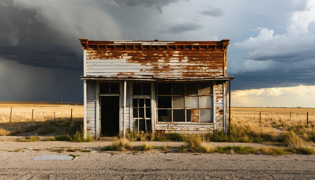
You’ll find abandoned treasures everywhere: weathered storefronts, decaying facades, and a historic bridge that frames stunning scenic views.
For photography tips, arrive during golden hour when long shadows dramatize the decay beautifully. Visitor experiences here aren’t curated or commercialized — they’re raw and authentic.
That ghost town charm hits differently when you realize roughly 62 people still call this place home, making Roscoe something rarer than a ghost town: a living relic.
How to Get to Roscoe on Highway 30
Once you’ve felt the pull of Roscoe’s weathered streets, actually getting there’s invigoratingly straightforward. Your highway navigation couldn’t be simpler — just find US Highway 30, the legendary Lincoln Highway, and follow it into Keith County.
These travel tips will orient you fast:
- From Ogallala: Drive approximately 7 miles east on Highway 30, and Roscoe appears quietly on your right.
- Vehicle requirements: Any standard 2WD vehicle handles the route year-round, no special equipment needed.
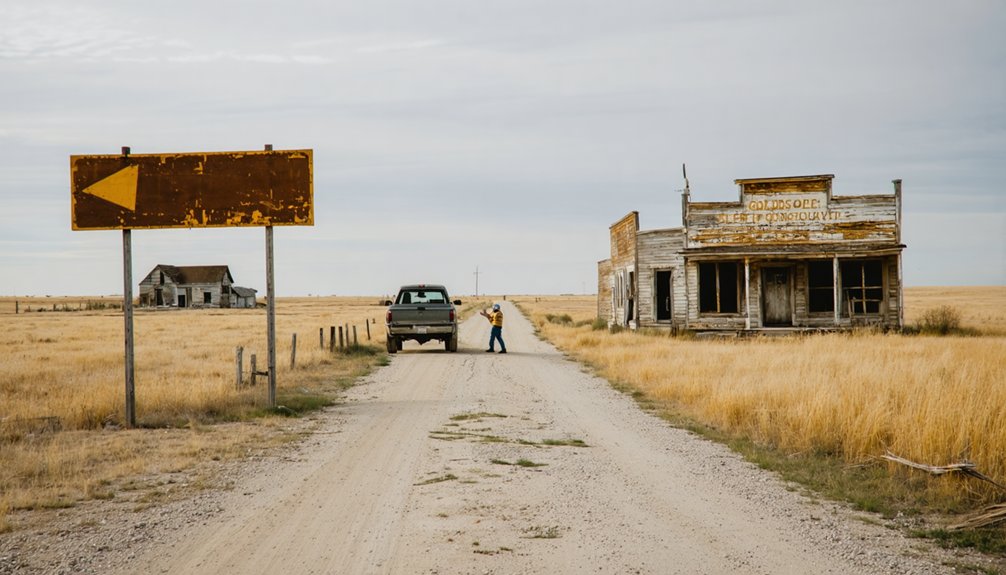
- Watch carefully: Roscoe’s tiny 5-block footprint means blinking equals missing it entirely.
Interstate 80 runs just 0.5 miles south, so you’ll exit that corridor and step back into a slower, rawer America.
The South Platte River valley will greet you, framing everything beautifully ahead.
The Oregon Trail History Behind Roscoe’s Rise and Fall
Standing beside the South Platte River today, you’d never guess this quiet stretch of water once drew thousands of westward migrants desperately searching for a crossing point.
Oregon Trail pioneers faced brutal travel challenges here, making historic crossings that shaped frontier life across the entire region.
Roscoe emerged from these migration patterns, growing as a practical stopping point rather than the trail’s premier crossing.
Roscoe grew not from ambition or vision, but from simple, stubborn geographic necessity.
Pioneer settlements like this one thrived on necessity, not preference. Cultural heritage ran deep here, fueled by desperation and determination in equal measure.
Then economic shifts dismantled everything.
The Lincoln Highway briefly revived Roscoe’s purpose, but Interstate 80‘s construction just half a mile south permanently redirected traffic flow.
What travelers once needed, they could now bypass entirely — and they did.
Abandoned Buildings You’ll Actually Find in Roscoe
That economic abandonment didn’t vanish into abstraction — it left physical evidence scattered across five blocks of Highway 30 that you can walk through today. These abandoned structures tell Roscoe’s story more honestly than any historical marker could.
Here’s what you’ll actually encounter:
- Crumbling storefronts with collapsed facades and weathered signage frozen mid-decay
- The historic South Platte River bridge, still standing and framing incredible long-exposure shots
- Mixed residential and commercial ruins sitting side-by-side, each in different stages of deterioration
For photography tips, arrive during golden hour when Nebraska’s flat light rakes dramatically across broken windows and peeling wood.
You’ll want a wide-angle lens to capture the emptiness stretching between structures. The silence here isn’t sad — it’s honest freedom from anything manufactured for tourists.
How Long Does a Visit to Roscoe Actually Take?
You can cover Roscoe’s roughly five blocks of abandoned storefronts and historic structures in about 30 to 45 minutes at a relaxed pace.
If you’re serious about photographing the crumbling architecture or exploring the South Platte River bridge, budget closer to an hour.
Pair your stop with a drive along the surrounding Highway 30 corridor to make the most of your detour off I-80.
Typical Visit Duration
Five blocks — that’s all there’s to Roscoe, and most visitors cover the entire town in under an hour. Your visit duration depends entirely on how deep you want to go with your exploration.
Here are some tips to help you plan:
- Quick stop (20–30 minutes): Drive through, photograph the crumbling storefronts, and keep moving down Highway 30.
- Standard visit (45–60 minutes): Walk the blocks, examine the abandoned structures up close, and cross the historic South Platte River bridge.
- Deep exploration (1–2 hours): Document everything — weathered facades, forgotten details, and the quiet atmosphere that makes ghost towns worth chasing.
There’s no admission fee, no schedule, and no crowds. You’re free to move at your own pace through this forgotten stretch of Nebraska.
Maximizing Your Time
Knowing how long to spend somewhere shapes the entire experience — and Roscoe rewards those who resist the urge to rush.
Walk the full five blocks slowly. Read the decay like a story. Each crumbling storefront carries historical significance that highway speed strips away entirely.
Let yourself wonder about the people who once moved through these streets, chased by local legends of a town that Highway 30 built and Interstate 80 quietly abandoned.
Photograph what catches your eye. Pause at the historic bridge. Feel the South Platte River wind cutting through the valley.
You’re not checking boxes here — you’re reclaiming time on your own terms. Give Roscoe an honest hour, and it’ll give you something worth carrying home.
The Best Time of Year to Visit Roscoe, Nebraska
Roscoe welcomes visitors year-round, and since it’s accessible by standard 2WD vehicles, you won’t need to worry about road conditions dictating your trip.
Each season offers a distinct experience across the best seasons for exploration:
Every season transforms Roscoe differently — each visit its own chapter in the town’s quiet, forgotten story.
- Spring and Fall deliver mild temperatures and soft, golden light that makes abandoned storefronts and crumbling facades ideal for photography.
- Summer brings warm, expansive skies over the South Platte River valley, giving the ghost town an almost cinematic atmosphere.
- Winter wraps Roscoe in snow and silence, stripping away distraction and intensifying the town’s haunting, forgotten character.
There aren’t local events tying you to a specific date, so your schedule stays completely yours.
Go whenever the open road calls.
How to Photograph Roscoe’s Crumbling Storefronts
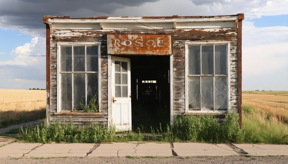
Crumbling storefronts line roughly five blocks of Highway 30, giving you a compact shooting environment where tight framing and deliberate angles matter more than distance.
Apply photography tips like shooting during golden hour, when low light carves texture into weathered wood and peeling paint.
Composition techniques involving leading lines work naturally here — follow deteriorating facades, broken window frames, or cracked sidewalks toward a vanishing point.
Get low, shoot upward, and let decaying architecture dominate your frame. The historic South Platte River bridge adds structural contrast if you want wider environmental shots.
Bring a wide-angle lens for storefronts and a telephoto for isolating specific details like rusted signage or collapsed doorways.
Since the area’s compact, you can cover every angle on foot without moving your vehicle.
Which Nebraska Ghost Towns Are Worth Adding to Your Route?
Nebraska’s ghost towns stretch across the High Plains like forgotten chapters of a westward migration story, and Roscoe fits naturally into a broader road trip circuit that rewards curious explorers.
You’ll find worthwhile stops at places like Pawnee City, Brownville, and Junction City, each offering their own abandoned storefronts, crumbling foundations, and quiet atmosphere that echoes Nebraska’s boom-and-bust past.
To plan your route efficiently, map your stops along Highway 30 and Interstate 80’s corridor, where history and accessibility align to make multi-town exploration both practical and deeply rewarding.
Nebraska Ghost Towns Overview
While Roscoe makes for a compelling detour, it’s far from the only ghost town worth tracking down across Nebraska. The state’s rural decay tells a bigger story about economic shifts that hollowed out dozens of once-thriving communities.
You’ll find ghost town culture woven into Nebraska history across forgotten crossroads and abandoned main streets.
Here are three stops worth adding to your scenic routes:
- Brownville – Rich in historical significance and local legends along the Missouri River
- Milligan – A quiet study in rural photography tips and crumbling architecture
- Anselmo – Where economic shifts stripped away commerce, leaving eerie, photogenic emptiness
Each destination rewards curious travelers who crave open roads, authentic history, and the kind of freedom that only wide Nebraska skies can deliver.
Top Ghost Towns Nearby
Beyond Roscoe’s crumbling storefronts, Nebraska rewards ghost town hunters with a loose circuit of forgotten communities scattered across its rural landscape.
You’ll find Lowell, Lisco, and Antioch within reasonable driving distance, each offering abandoned structures and quiet, windswept atmosphere worth your camera’s attention. These nearby attractions share Roscoe’s characteristic emptiness — businesses shuttered, populations vanished, highways bypassed.
Travel tips worth remembering: stick to US Highway 30 and old Lincoln Highway corridors rather than Interstate 80, since original routes reveal more forgotten settlements.
Download offline maps before departing Ogallala, because cell service disappears without warning in Keith County’s open terrain. You’re building your own itinerary here, connecting dots between communities that commerce and modernity abandoned.
That freedom — no crowds, no admission fees, no schedules — defines Nebraska ghost town exploration perfectly.
Planning Your Ghost Town Route
Planning a ghost town route through Nebraska means committing to the state’s loneliest highways and most rewarding stretches of forgotten Americana.
US Highway 30 becomes your spine, threading through ghost town culture that Interstate 80 travelers never witness. Rural exploration here rewards the intentional traveler.
Structure your route around these essentials:
- Anchor to Highway 30 — Roscoe sits 7 miles east of Ogallala, making it a natural waypoint between western Nebraska stops.
- Travel light and flexible — All roads into these towns accommodate 2WD vehicles year-round, so no specialized equipment limits your freedom.
- Chase the golden hours — Morning and late afternoon light transforms crumbling storefronts into compelling photographs worth stopping for.
Nebraska doesn’t announce itself. You have to choose it deliberately.
What to Know Before You Drive Out to Roscoe
Before you point your car toward Roscoe, there are a few things worth knowing. It sits along US Highway 30, roughly 7 miles east of Ogallala in Keith County, Nebraska. Your standard 2WD vehicle handles the route year-round, so heavy road trip essentials like four-wheel drive aren’t necessary.
Blink, though, and you’ll miss it — the entire town spans just 0.16 square miles and five blocks.
Interstate 80 runs half a mile south, meaning most travelers never stumble onto it. That isolation is exactly the draw. Local legends tied to Oregon Trail crossings still echo through the crumbling storefronts and the historic South Platte River bridge.
Roughly 62 residents remain, making Roscoe a semi-ghost town — quiet, unhurried, and entirely yours to explore.
Frequently Asked Questions
Is Roscoe, Nebraska Still Technically an Incorporated Town Today?
Yes, Roscoe still maintains its technical incorporation status today, despite its dwindling town demographics of roughly 62 residents. You’ll find its historical significance preserved in crumbling storefronts, proving small towns stubbornly refuse to fully disappear.
How Many People Actually Still Live in Roscoe, Nebraska?
You’ll find only about 62 souls still calling Roscoe home, a reflection of rural population trends. Despite its sparse residents, you can explore local attractions like hauntingly abandoned storefronts frozen beautifully in time.
Does Interstate 80 Pass Directly Through Roscoe, Nebraska?
No, Interstate 80 doesn’t pass through Roscoe — it runs half a mile south. On your ghost town road trip, you’ll find this quietly abandoned treasure along historic Highway 30, bypassed and beautifully forgotten.
Can 2WD Vehicles Safely Access Roscoe Year-Round Without Issues?
You’ll have no trouble reaching Roscoe in your 2WD vehicle year-round! Road conditions along US Highway 30 welcome standard vehicles, making this hauntingly beautiful ghost town accessible whenever wanderlust strikes—no special vehicle recommendations needed for your adventure.
Was Roscoe Ever the Most Popular Oregon Trail River Crossing?
Can you imagine the struggle of pioneer settlements choosing river crossings? Roscoe’s Oregon Trail historic significance is real, but it wasn’t the most popular. Other locations offered better crossings for westward-bound travelers seeking freedom.
References
- https://www.youtube.com/watch?v=l3s2qhSxis8
- https://www.ghosttowns.com/states/ne/roscoe.html
- https://www.youtube.com/playlist?list=PL4jqwLUrhjNRfJY3fBbmmCW98ilUDWBGN
- https://www.instagram.com/p/DVALjTyju-r/
- https://www.placesthatwere.com/2016/07/abandoned-relics-of-past-in-roscoe.html
- https://www.instagram.com/reel/DVBS9_2DsgI/
- https://www.facebook.com/therealdiaryofabandonment/posts/the-ghost-town-vibes-of-roscoe-nebraska-/122165520116773007/
- https://www.pinterest.com/pin/12103492740734884/
- https://commons.wikimedia.org/wiki/File:”Stories_to_Tell”_Roscoe
- https://www.facebook.com/therealdiaryofabandonment/photos/the-ghost-town-vibes-of-roscoe-nebraska-/122165520086773007/


