
You’ll find Texon 85 miles west of San Angelo via U.S. Highway 67 and State Highway 137, where the Permian Basin‘s first planned company town sits abandoned at coordinates 31.4617, -102.4239. Once home to 1,200 oil workers who enjoyed swimming pools and electric lights in 1920s West Texas, Texon’s silent school and crumbling storefronts now stand witness to boom-turned-bust history. The nearest services wait 10 miles away in Rankin, so you’ll need proper preparation to explore what lies within these time-frozen ruins.
Key Takeaways
- Texon is located 85 miles west of San Angelo via U.S. Highway 67 and State Highway 137 in Reagan County.
- The abandoned 1920s oil town features vacant buildings, silent schoolhouses, and derricks along its original street grid.
- No utilities exist at the site; nearest services are 10 miles away in Rankin, requiring full self-sufficiency preparation.
- Winter offers milder conditions than summer heat, but sudden weather changes necessitate emergency supplies and road monitoring.
- Check TxDOT cameras or call (800) 452-9292 for road conditions before visiting this remote Edwards Plateau location.
The Rise and Fall of a Model Oil Community
The discovery of black gold beneath West Texas scrubland in May 1923 set an improbable chain of events into motion. Santa Rita #1 birthed the Big Lake oilfield, where Pittsburgh oilmen M. L. Benedum and Joe Trees recognized potential beyond mere extraction. Their vision transcended the role of oilfield engineering—they’d build civilization itself.
By 1924, Texon emerged as the Permian Basin’s first planned company town. Levi Smith orchestrated its transformation: electric lights, piped water, swimming pools, and bowling alleys appeared where sagebrush once dominated. The cultural significance of community planning replaced typical oil-town chaos with order and prosperity. The company even organized semi-pro baseball, fielding the Texon Oilers with former college athletes and seasoned players hired on a full-time work/play basis.
At its 1933 peak, 1,200 souls called Texon home. But oil fields don’t flow forever. Production dwindled post-WWII, Marathon Oil abandoned maintenance in 1962, and the post office shuttered in 1986. By 2000, only 12 residents remained in what had once been a thriving model community. Freedom’s price: impermanence.
What Remains of Texon Today
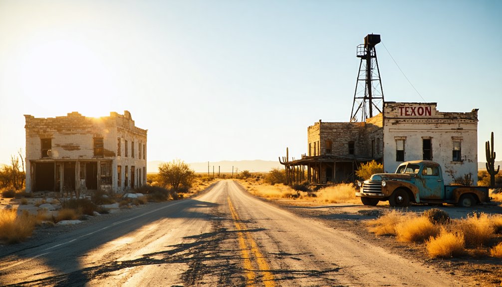
When you arrive at Texon today, dust devils dance across vacant lots where children once played beneath streetlights—a rare luxury in 1920s West Texas. Fewer than 10 souls remain among concrete foundations and weathered facades that once sheltered 2,000 residents.
You’ll find the old school building standing silent, its windows watching over empty streets that still follow the company’s original grid. Crumbling store fronts and abandoned derricks tell residents’ stories without words. The houses that survive showcase the architectural ambition of Big Lake Oil Company’s model community, now slowly surrendering to wind and sand.
Preserved artifacts hide within collapsing structures—rusted tools, faded photographs, forgotten machinery. No utilities reach these ruins anymore; the nearest services wait 10 miles away in Rankin, making exploration feel genuinely remote. While Texon represents Texas’s oil boom past, 75 Texas counties experienced population losses from 2022-2023, showing that decline extends beyond historic ghost towns into modern communities. Like Thurber’s shift when oil and gas replaced coal, energy market changes determined which Texas towns would thrive and which would fade into memory.
Getting to Texon: Directions and Route Planning
You’ll find Texon tucked into the remote Edwards Plateau of southwestern Reagan County, accessible primarily via U.S. Highway 67 and State Highway 137. From San Angelo, the journey stretches 85 miles westward through oil country, where weathered pump jacks dot the mesquite-studded landscape.
Once you turn onto the local ranch roads near Big Lake, expect unpaved surfaces and isolation—this ghost town sits far from interstate corridors, demanding careful route planning and a full gas tank. The precise coordinates place Texon at 31.4617 latitude and -102.4239 longitude, helping modern GPS navigation systems guide you to this nearly forgotten settlement. Along your route, you’ll pass Pipeline Tank, a reservoir sitting at approximately 2,769 feet elevation in the surrounding terrain.
Primary Highway Routes
Ribbons of asphalt stretch across West Texas rangeland, guiding modern travelers toward a place frozen in oil-boom memory. US Highway 67 cuts through Reagan County as your primary artery, connecting San Angelo’s civilization to Texon’s skeletal remains eighty-five miles westward.
You’ll spot FM 1657 peeling southward—a three-tenths-mile spur that delivers you directly to history’s doorstep, where Santa Rita No.1’s derrick still punctures the horizon.
These scenic access routes demand respect. Seasonal weather patterns transform quickly here: summer heat shimmers off pavement at 110°F while winter blue northers howl across exposed stretches. There’s no interstate luxury, just state highways threading through emptiness. Your coordinates point to 31°13’30″N, 101°41’22″W, approximately fifteen miles west of Big Lake.
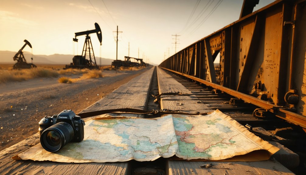
The old Kansas City, Mexico and Orient Railway tracks parallel your path, marking where wildcatters once rode steel rails toward fortune. Nearby Stiles in Reagan County had a population of four persons in 2000, testament to the sparse settlement pattern that defines this region.
From Major Texas Cities
Four major metropolitan areas anchor your journey to this Reagan County relic, each offering distinct landscapes that shift beneath your wheels. From San Angelo, you’ll trace 85 miles westward—the shortest path for weekend itineraries seeking quick escapes.
Dallas drivers commit to 350+ miles of southward movement through Midland’s oil country, while Austin explorers chart 280 miles through Hill Country before angling northwest toward US 67.
Houston presents the ultimate freedom seeker’s challenge: 450 miles of Texas plains unfolding across I-10’s westward sweep. Each route transforms into one of Texas’s most rewarding scenic driving routes, converging at that critical junction where RM 1675 branches south.
Your destination waits three-tenths of a mile from the highway, where Texon’s weathered structures stand sentinel in Reagan County’s forgotten corner. The town sits at coordinates 31.3333° N, 101.4833° W, pinpointing its location in the heart of West Texas’s Permian Basin. The town once welcomed visitors via the Kansas City, Mexico and Orient Railway, which connected this oil boom settlement to broader commercial networks across the region.
Local Road Conditions
Before your wheels ever touch Reagan County’s caliche, West Texas weather patterns demand your respect and preparation. Though Texon sees fewer winter storms than northern regions, sudden freezes transform remote ranch roads into hazardous passages. Road maintenance here operates on vast distances—crews prioritize main arteries while backroads wait. Check DriveTexas.org before departing, monitoring real-time conditions through their interactive map.
Essential winter driving conditions preparation includes:
- Monitoring TxDOT cameras for live highway views
- Calling (800) 452-9292 for automated road updates
- Watching for ice accumulation on bridges and cattle guards
- Maintaining emergency supplies: water, blankets, charged phone
- Allowing extra travel time during cold fronts
These empty stretches offer no quick rescues. Your self-reliance becomes paramount when civilization disappears behind mesquite-dotted horizons.
Best Time to Visit This West Texas Ghost Town
When the West Texas sun slants low across Texon’s abandoned streets, the ghost town reveals different moods depending on the season you choose to visit. For those seeking unique experiences, the ghost town attractions in Best, Texas offer a glimpse into the past, revealing stories of old settlers and bygone eras. Whether you wander through decaying structures or participate in seasonal events, each visit is a new adventure steeped in history. Don’t forget to capture the stunning sunset views that paint the landscape in vibrant colors, making it a perfect backdrop for exploration. As you explore abandoned sites in Caddo, you may stumble upon remnants of old railroads and forgotten residences that whisper tales of a thriving community. Each corner holds relics of the past, inviting curious minds to delve deeper into the region’s history. The air is thick with nostalgia, evoking a sense of wonder about the lives once lived in these now-silent spaces.
Texon’s weathered facades shift in character as seasons transform the abandoned oil town from scorching wasteland to photographer’s paradise.
The best season to visit spans October through April, when temperatures drop from summer’s punishing 113°F to comfortable 60s and 70s. You’ll find the ideal months for exploration in late October and November—clear skies frame crumbling structures perfectly, and you’ll spot wildlife moving through abandoned buildings.
Spring brings wildflowers threading through rusted machinery, while winter’s cold nights create prime stargazing conditions above the desolate landscape. February through April offers peaceful solitude with minimal crowds.
Avoid May through August unless you’re comfortable exploring during extreme heat that transforms these ruins into a shimmering mirage.
What to Bring for Your Exploration
Your Texon expedition demands careful preparation, as this remote Reagan County ghost town sits 85 miles from the nearest city with limited cell service and no amenities. When you explore ghost towns in Texas, you’ll uncover a rich history that adds to the allure of desolation. Beyond Texon, there are numerous abandoned settlements, each with its own storied past waiting to be discovered. Be sure to travel with a reliable map and adequate supplies, as some locations are truly off the beaten path and may offer little in terms of modern conveniences. As you explore the ghost town of Las Cabras, you’ll be captivated by the eerie silence that envelops the crumbling buildings and dusty streets. The stories whispered by the wind are reminders of the lives once lived in this desolate place, making it a perfect spot for adventurous souls seeking a glimpse into Texas’s forgotten past. Don’t forget your camera, as the haunting beauty of Las Cabras offers countless opportunities for stunning photographs that capture the essence of this hidden gem.
The unforgiving West Texas desert environment requires you to pack layers that traverse from scorching midday sun to sudden evening temperature drops, while sturdy boots protect against debris scattered across abandoned oil field roads.
Between maneuvering to coordinates 31.222387, -101.692625 and documenting the crumbling structures near the historic Santa Rita No.1 site, you’ll need gear that keeps you safe, oriented, and comfortable in conditions that show no mercy to unprepared explorers.
The crunch of broken glass beneath inadequate footwear has ended more than one ghost town exploration prematurely. Before venturing into Texon’s abandoned structures, appropriate protective measures start with your foundation: sturdy boots with thick soles, long sleeves, and cut-resistant gloves shield you from hazards lurking in decay.
Your essential gear list should include:
- Headlamp or flashlight to pierce the darkness of windowless buildings
- Dust mask or respirator protecting against mold and airborne particles
- Offline maps and marking chalk for navigation when signals fail
- First aid kit with bandages, antiseptic, and emergency supplies
- Safety helmet defending against crumbling ceilings
Suggested safety inspections of each structure before entry aren’t paranoia—they’re survival instinct. Pack light, move deliberately, and always maintain clear exit paths.
Photography and Documentation Equipment
Abandoned structures reveal their secrets only to those prepared to capture them, and documentation equipment separates casual snapshots from compelling visual narratives. You’ll need manual-focus lenses—wide-angle glass for sweeping architectural contexts, telephoto zooms for isolated details.
A sturdy tripod enables long exposures that transform Texon’s ruins into ethereal compositions. Remote triggers eliminate camera shake during extended night shots, while off-camera flash systems breathe dimension into shadowed interiors.
Camera bag types range from weatherproof backpacks to modular sling designs; choose configurations protecting gear from relentless dust. Battery management strategies prove critical—desert heat drains power cells rapidly, so carry extras in insulated pouches.
Neutral density filters create motion blur in daylight, graduated versions balance harsh desert skies. Pack sensor cleaning kits, backup storage media, and lens cloths—preparation transforms exploration into artistry.
Comfort Items for Desert Conditions
Desert survival hinges on three elements that separate confident explorers from those airlifted to safety: water abundance, thermal regulation, and protection from relentless elements that transform Texon’s ruins from romantic backdrop to legitimate hazard.
Your comfort arsenal demands strategic selection:
- Hydration systems: Pack at least one gallon daily, plus purification tablets for long term hydration independence
- Thermal layering: Light-colored, loose-fitting clothes with high UPF rating paired with wool jacket for brutal night drops
- Sun defense: Wide-brimmed hat with chinstrap, bandanas, and neck gaiter offering versatile protection
- Emergency shelter: Reflective blankets and tarps create shade havens during midday scorchers
- Fabric durability: Convertible pants with reinforced knees withstand sharp ruins and thorny desert flora
These essentials transform harsh conditions into manageable adventure parameters.
Nearby Ghost Towns and Oil Heritage Sites Worth Visiting
Beyond Texon’s crumbling streets, Reagan County harbors a constellation of oil-boom relics that tell the story of West Texas’s wildest era. You’ll find Best—ironically named for its notorious reputation—seven miles southwest, where gambling dens and violence once thrived amid oil field innovations.
Stiles stands farther north, its torched courthouse ruins punctuating the desert silence. The Santa Rita No. 1 monument marks where Texas’s petroleum empire ignited, its preserved derrick towering over scrubland.
Hadacol Corners offers abandoned ballpark ruins and a skeletal filling station that once served as one of the regional transportation hubs. Thread these coordinates together on your motorcycle, connecting dots across seventy miles of raw terrain where fortunes were struck and squandered, where civilization flickered briefly before the desert reclaimed its dominion.
Photography Tips for Capturing Texon’s Ruins
When sunlight rakes across Texon’s skeletal facades, your camera becomes archaeology’s instrument, translating cracked plaster and weathered timber into narratives of boom-time hubris and inevitable decay. Immersive visual storytelling demands technical precision matched with reverence for historical context preservation.
Each photograph excavates memory from ruin, where light and shadow collaborate to document what commerce built and time reclaimed.
Essential approaches for documenting these ruins:
- Deploy wide-angle lenses during golden hour to capture town overviews with softer directional light
- Bracket exposures in high-contrast scenes, enabling HDR post-processing that reveals both shadow details and sky textures
- Frame compositions through doorways and arches, adding layered depth to abandoned interiors
- Shoot RAW format at lowest ISO for maximum post-adjustment flexibility
- Target architectural remnants—ornate doorknobs, weathered signage, crumbling staircases—that whisper individual stories
Low angles emphasize spatial vastness while telephoto compression dramatizes isolation against vast Texas horizons.
Frequently Asked Questions
Is Overnight Camping Allowed Near the Texon Ruins?
Like a shadow fading at dawn, overnight facilities near Texon’s ruins don’t exist. You’ll find the historical significance best appreciated as a day trip, requiring you to seek camping elsewhere in designated Texas areas where freedom responsibly meets preservation.
Are There Any Guided Tours Available for the Ghost Town Site?
No guided tours by local historians operate at Texon currently. You’ll explore independently, wandering oil-boom ruins at your own pace. Unlike nearby Terlingua’s self-guided walking tours around town, Texon offers pure, unstructured adventure through crumbling history.
Do I Need Permission to Access the Former Town Area?
You’ll need permission since Texon sits on private property. Private property concerns and liability considerations make unauthorized access risky. Contact local landowners beforehand—they’ll often grant access to respectful explorers seeking authentic remnants of this oil-boom ghost town.
Are There Any Restrooms or Facilities Available at the Site?
No facilities exist at this windswept ghost town—wheelchair accessibility and nearby dining options vanished with Texon’s 2,000 residents decades ago. You’ll find only desert silence, rusting derricks, and freedom from civilization’s conveniences here.
Is Cell Phone Reception Available in This Remote Area?
Cell phone reception exists but varies considerably. You’ll find AT&T and Verizon offer the strongest network coverage in Texon’s remote terrain. Signal strength fluctuates unpredictably—toggle airplane mode to reconnect when bars disappear into the desert silence.
References
- https://www.tshaonline.org/handbook/entries/texon-tx
- https://www.county.org/county-magazine-articles/summer-2025/ghost-towns
- https://www.ghosttowns.com/states/tx/texon.html
- https://www.texasstandard.org/stories/best-texas-the-ghost-town-with-the-worst-reputation/
- https://cedarbayoumarina.com/four-ghost-towns-under-lake-texoma/
- https://en.wikipedia.org/wiki/Texon
- https://www.youtube.com/watch?v=chI0O2VvGTI
- https://thebullamarillo.com/ixp/185/p/an-amazing-look-at-10-texas-ghost-towns-that-once-stood-proud/
- https://www.texasescapes.com/TOWNS/Texas_ghost_towns/Texon_Texas/Texon_Texas.htm
- https://pboilandgasmagazine.com/a-company-town-for-the-ages/


