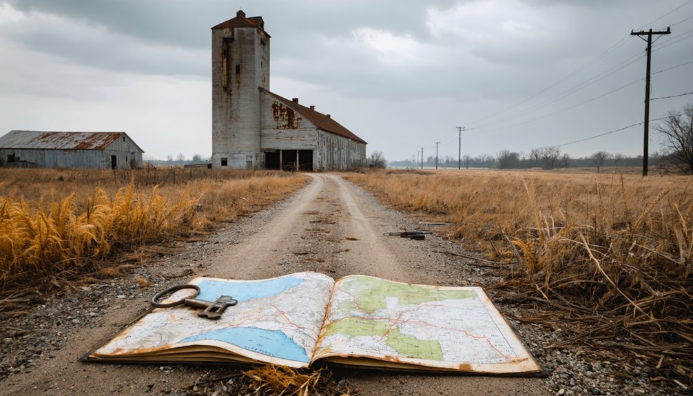
Your ghost town road trip through Tippecanoe County starts at Fort Ouiatenon’s 216-acre archaeological sites, then winds through Harrisonville’s cemetery markers and LaGrange’s eight phantom streets on the Great Wea Plains. You’ll discover Little Chicago’s Underground Railroad station along the Wabash River, explore Granville Cemetery’s 379 burials revealing boom-and-bust cycles, and locate Corwin Station’s vanished grain elevators at coordinates 40°15’5″ North, 86°54’52” West. Pack sturdy boots, headlamps, and dust masks as you uncover the complete stories behind these abandoned settlements.
Key Takeaways
- Visit Fort Ouiatenon’s 216-acre archaeological site to explore preserved Native village artifacts from Wea, Kickapoo, and Mascouten communities.
- Explore Granville Cemetery’s 379 documented burials revealing frontier prosperity through ornate Victorian markers and evidence of 1850s decline.
- Tour Little Chicago’s restored Buddell Sleeper house, a vital Underground Railroad station with concealed rooms that sheltered freedom seekers.
- Bring essential gear: sturdy boots, headlamp, cut-resistant gloves, dust respirator mask, first-aid kit, and multi-tool for safe exploration.
- Document Yorktown Cemetery at Columbia and Dayton streets intersection and Corwin Station ghost town at coordinates 40°15’5″N, 86°54’52″W.
Understanding Tippecanoe County’s Lost Communities
Before Interstate highways and railway lines carved up the American Midwest, Native villages and frontier settlements dotted Tippecanoe County’s landscape with a liveliness that’s hard to imagine today. You’ll find archaeological discoveries that tell stories of thriving Wea, Kickapoo, and Mascouten communities along the Wabash River, where over 1,000 Natives traded furs at Fort Ouiatenon from 1717 until 1791’s devastating Blackberry Campaign. Remote sensing technology recently revealed village artifacts outside the fort’s walls across 216 acres of preserved sites.
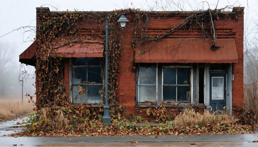
Beyond these Native settlements, ambitious frontier towns like LaGrange, Little Chicago, and Yorktown rose and fell with riverboat trade and railroad routes. When infrastructure bypassed these communities, prosperity vanished. Today, you’ll discover only farmland, a single modernized house, and historical photographs marking where complete towns once stood.
Harrisonville: Where John Burget’s 1834 Settlement Once Stood
When John Burget staked his claim in 1834, he envisioned Harrisonville as more than just another frontier outpost—he saw a thriving hub where settlers would build lasting legacies along Tippecanoe County’s promising landscape.
You’ll find founding documents listing pioneer settlers like Peleg Babcock, John Roberts, and Thomas Watson who joined Burget’s venture. The post office opened in 1835, signaling legitimate community status. Yet Harrisonville’s independence proved fleeting—Battle Ground’s proximity gradually absorbed the settlement into obscurity.
Today, you’ll discover only cemetery markers referencing this ghost town, including Jane Murphy’s February 1834 burial. Standing near Battle Ground, you’re treading ground where ambitious founders once mapped streets that never materialized. Their dream dissolved, but the pioneer spirit they embodied still resonates through Tippecanoe County’s history.
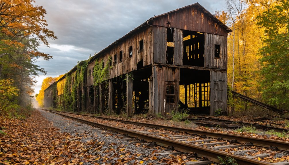
Little Chicago: The Underground Railroad House That Remains
You’ll find the remnants of Little Chicago’s most remarkable structure on County Road W 700 S, where Buddell Sleeper’s house once concealed freedom seekers in hidden rooms designed to evade slave catchers.
The Quaker settlement operated this vital Underground Railroad station through the 1850s, funneling escaped slaves north to Canada along the Wabash River valley route. Though the original marker has been replaced, you can still locate this memorial to Tippecanoe County’s abolitionist past at coordinates 40° 18.942′ N, 87° 0.473′ W near Westpoint.
Hidden Room History
Deep in the Tippecanoe County countryside near Westpoint, a trap door once concealed freedom seekers beneath bags of wheat in the Sleeper family home. Buddell Sleeper, born in 1806, transformed his property at coordinates 40° 18.942′ N, 87° 0.473′ W into a critical underground railroad route station.
You’ll find a historical marker commemorating where the Quaker family operated these concealed shelter spaces during the pre-Civil War era.
The Sleepers’ ingenuity saved countless lives. When slave catchers prowled nearby, runaways descended through that hidden floor opening while wheat sacks provided additional camouflage.
This Tippecanoe County station connected to broader networks stretching from southern Indiana’s river towns toward Canadian freedom. Today, you can visit the site where Buddell and Elizabeth Sleeper risked everything, their courage embedded in soil that once whispered hope.
Finding the Remnant House
A single structure still stands in Little Chicago, its weathered frame the last physical witness to Tippecanoe County’s Underground Railroad network. The Buddell Sleeper home, built by a New York-born Quaker who settled here in the 1830s, served freedom seekers traveling north to Canada.
You’ll find this remnant house restoration project preserving underground railroad connections that once stretched from the Ohio River through central Indiana.
What Makes This Site Significant:
- Operated by Farmers Institute Monthly Meeting of Friends community
- Connected to routes leading through Indianapolis, Westfield, and Logansport
- Part of network that aided thousands before the Civil War
- One of few documented Quaker stations in Tippecanoe County
- Maintained dangerous operations even after the 1850 Fugitive Slave Act
Stand where conductors once risked everything for liberty.
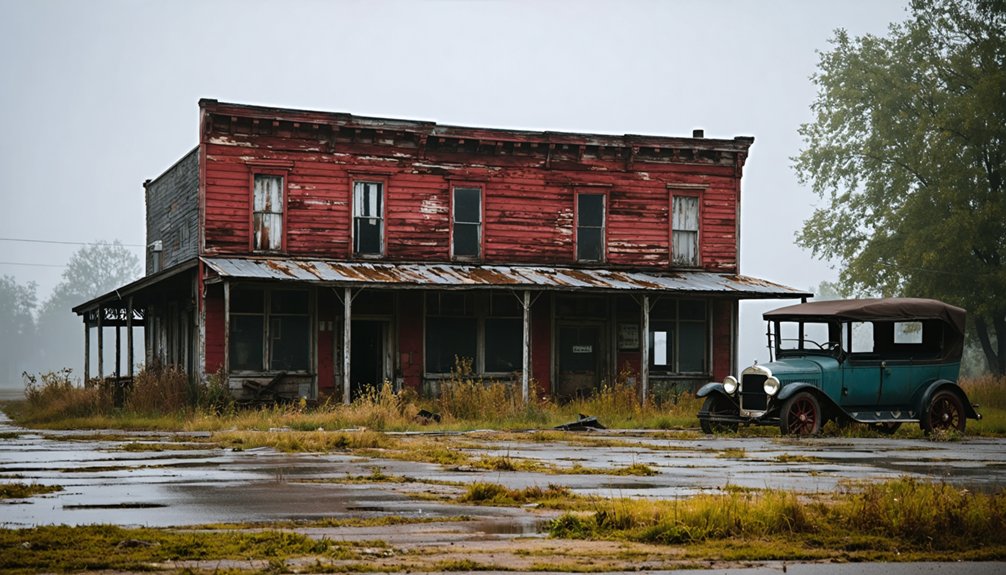
LaGrange on the Great Wea Plains: From Bustling Streets to Silence
You’ll find the remnants of LaGrange scattered across the Great Wea Plains, where eight named streets once bustled with settlers who’d built a proper hotel to serve travelers.
The town seemed poised for prosperity until the railroad chose a different route, slicing through its lifeline like a surgeon’s scalpel. Within years, those eight streets emptied as families packed their belongings and followed the steel rails to settlements that promised a future LaGrange could no longer deliver.
Eight Streets and Hotel
Standing where eight carefully platted streets once crisscrossed the Great Wea Plains, you’ll find nothing but windswept grassland and that solitary historical marker. The LaGrange Phalanx’s eight street layout embodied Charles Fourier’s utopian vision—each avenue representing equal investment and shared labor among community members. At its heart stood a hotel that served the association’s needs.
Between 1843 and 1848, this structured community thrived before vanishing completely:
- Fourier’s principles guided the geometric street design
- Shared labor along designated thoroughfares
- Hotel architecture anchored community gatherings
- Equal investment determined property access
- Five-year existence before total abandonment
Today at 41°38’31.3″N 85°15’53.8″W along Route 20, you’re free to wander where those eight streets once channeled humanity’s hopeful experiment in collective living—now reclaimed by prairie grasses.
Railroad Bypassed the Town
The dreams encoded in those eight streets couldn’t survive what happened next—or rather, what *didn’t* happen. When the Wabash Railroad carved its path in the 1850s, engineers chose the opposite bank of the river. That single decision sealed LaGrange’s fate. You can trace the town layout today—those phantom streets running perpendicular to the water—and imagine the desperation as residents watched trains thunder past on the far shore.
The hotel emptied. Merchants packed up. By the 1860s, the economic decline was terminal. The post office had already closed decades earlier, and now even the river trade couldn’t sustain what the railroad had abandoned. LaGrange didn’t burn or flood—it simply starved, left behind while prosperity rolled elsewhere on iron rails.
Granville: Windswept Tombstones in the Wabash River Valley
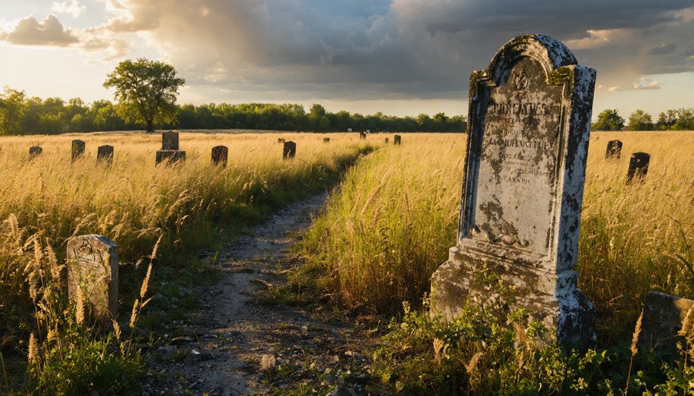
When you turn onto County Road 75S and drive a quarter-mile east from County Road 700W, windswept prairie grass gives way to rows of weathered tombstones marking what remains of Granville. You’re standing where the Wea tribe’s Ouiatenon villages thrived before 1834, when settlers established their own town here.
The cemetery tells Granville’s complete story:
- 379 documented burials spanning boom and bust years
- Pre canal Native settlements visible after annual grass burns
- 1840s canal prosperity reflected in ornate Victorian markers
- 1850s decline evident in fewer, simpler stones
- Complete abandonment by 1870s leaving only this burial ground
These 19th century cemetery conditions—windswept, isolated, haunting—capture what drew you to Indiana’s ghost towns: authentic glimpses of lives lived beyond modern constraints.
Yorktown: Following the Caulkins Brothers’ Legacy
You’ll find Yorktown’s cemetery standing alone on Stockwell Road, the last physical trace of five brothers who journeyed from New York State in 1841 with dreams of building something permanent.
The weathered headstones mark where the Caulkins brothers and their fellow settlers—Ransom Johnson, William Bartholomew, and carpenter Nathaniel Barnes—carved out a community that thrived for decades before railroads chose other routes.
Just weeks before today, the final platted lots reverted to farmland, leaving only these graves to prove a town once existed here at all.
Cemetery Marks Town’s Past
Just north of Indiana 28 on Stockwell Road, Yorktown Cemetery rises from the surrounding farmland like a stone ledger documenting a vanished community. You’ll find remnant gravestones marking everyone from the five Caulkins Brothers who founded the town in 1841 to Swedish immigrants who arrived decades later.
The cemetery’s historical significance lies in its role as Yorktown’s last witness—the town’s platted lots recently returned to farmland, leaving only scattered buildings and these weathered markers.
The stones tell Yorktown’s complete story:
- Ransom Johnson and William Bartholomew among earliest settlers
- Village carpenter Nathaniel Barnes from founding era
- Swedish immigrants Nicholas Bredberg and Gustave Swanson
- Burials spanning town’s rise through railroad-driven decline
- Cemetery positioned where Columbia and Dayton streets once bustled
You’re standing where railroads refused to go, sealing Yorktown’s fate.
New York Settlers’ Vision
The five Caulkins Brothers stood on this empty prairie in 1841, envisioning streets and storefronts where knee-high grass rippled in the wind. They’d left New York State behind, carrying blueprints in their minds and determination in their hearts. Their New York heritage shaped everything—the grid layout, the business district design, even the town’s name honoring their origins.
You’ll find their agricultural background evident in the wide lots they platted, spaces generous enough for gardens and livestock. Ransom Johnson and William Bartholomew soon followed, drawn by the brothers’ ambitious vision. Nathaniel Barnes arrived with his carpenter’s tools, transforming their dreams into physical structures. These pioneers didn’t just build a town—they created a self-sufficient community where eastern business practices met frontier opportunity, proving five brothers could reshape an entire landscape.
Corwin Station: Grain Elevators and Phantom Lots
Standing at the coordinates 40°15’5″ North, 86°54’52” West, you’ll find little more than memories and empty earth where Cyrus Foltz once platted seven ambitious building lots in 1856. Later known as Corwin Station, this ghost town half a mile west of Romney tells its story through absence.
The grain elevator remnants that once towered here vanished in September 2016, leaving only phantom platted lots where dreams of commerce faded.
What You’ll Discover:
- Empty plots along the CSX north-south train line
- No permanent structures—just open land
- Historical maps showing the removed grain silo
- GNIS feature ID 446668 marking its existence
- ZIP code 47981 serving a town with zero residents
Time zone: UTC-5 (EST), UTC-4 (EDT) summer.
Mapping Your Route Through Abandoned Settlements
Beyond Corwin Station’s vanished grain elevators, four distinct ghost settlements await your discovery across Tippecanoe County’s river valleys and rural crossroads. Start at Fort Ouiatenon‘s 56-acre native village sites, where you’ll find communities buried by Wabash floods and reclaimed by forest.
Mapping historic canal routes leads you to Granville Cemetery, sole remnant of a 15-block town overlooking the river valley. Continue to Little Chicago on Country Road 750 S at Sleeper Road, where Buddell Sleeper’s modernized home still stands with its Underground Railroad basement intact. End at Yorktown Junction‘s deserted intersection, now just a crossroads photograph in county archives. You’re documenting archaeological discoveries across landscapes where prosperity vanished, leaving only bent tombstones and overgrown foundations.
What to Bring for Your Ghost Town Exploration

Before you venture into Tippecanoe County’s crumbling settlements, pack your exploration kit with the precision of an archaeologist entering a dig site. Your essential exploration gear separates reckless thrill-seekers from prepared adventurers who’ll actually make it back.
Must-Have Equipment:
- Sturdy boots with thick soles protect against nails and broken glass scattered through collapsed floors
- Headlamp and backup flashlight illuminate pitch-black interiors for abandoned structure photography
- Cut-resistant gloves shield your hands from rusty metal and jagged surfaces
- Dust respirator mask filters decades of accumulated mold and asbestos
- First-aid kit and multi-tool handle unexpected injuries and equipment repairs
I’ve learned the hard way that bringing a physical map and compass saves you when cell signals vanish. Pack water, mark your route, and always tell someone your destination.
Preserving the History of Tippecanoe’s Vanished Towns
The ghost towns scattered across Tippecanoe County aren’t just abandoned buildings—they’re irreplaceable time capsules that demand our protection before weather and vandals erase them completely.
You’ll find Greenbush Cemetery standing as a testament to preservation done right, where relocated graves from Lafayette’s original burial ground now rest alongside unmarked graves location markers for 30 Confederate POWs.
When you explore sites like Granville’s forgotten fields, you’re walking where Native American artifacts discovered reveal layers of Ouiatenon village history predating canal-era settlements.
Document what you encounter—photograph crumbling foundations, record GPS coordinates, report vandalism to county historical societies. These remnants connect us to warriors, merchants, and railroad dreamers who refused conformity. Your vigilance safeguards future generations inheriting these freedom-loving stories rather than empty, forgotten landscapes.
Frequently Asked Questions
Are Any of These Ghost Town Sites on Private Property?
Like scattered puzzle pieces across farmland, some sites require access permissions before exploring. You’ll need landowner agreements for Dresser and Kickapoo areas, while Corwin, Granville, and Heath remain publicly accessible. Always respect posted boundaries during your adventure.
What’s the Best Time of Year to Visit These Abandoned Settlements?
You’ll find the best weather conditions during spring and fall—ideal visitation periods when 50-70°F temperatures let you roam freely without summer’s oppressive humidity or winter’s treacherous ice limiting your exploration of Tippecanoe’s forgotten settlements.
Can I Legally Explore the Remaining Structures at These Sites?
You’ll need owner permission for private structures, but cemeteries remain accessible. Investigate local trespass laws before venturing onto posted land, and inquire about visitor policies at state-managed sites like Hindostan Falls for worry-free exploration adventures.
How Long Does It Take to Visit All Six Ghost Towns?
You’ll knock it out in about 4 hours total—2 hours driving, 2 hours exploring. Travel time between sites is short, though site accessibility varies wildly. Some cemeteries welcome wanderers; others hide behind private farmland requiring permission first.
Are There Guided Tours Available for These Historic Locations?
You’ll find limited guided tours offered for Tippecanoe’s ghost towns themselves. However, self-guided tours available at Tippecanoe Battlefield Park let you explore independently with detailed brochures, giving you freedom to wander at your own pace.