You’ll find Sloan as a former railroad settlement in Jordan Township, Warren County, Indiana, established in 1903 along the New York Central Railroad line. The town flourished with a post office (1914-1941), grain elevator, and general store, serving as an essential agricultural shipping hub between Indianapolis and Chicago. By the late 20th century, changing transportation patterns led to its decline, leaving behind abandoned tracks and empty buildings – remnants of a once-bustling community with untold stories.
Key Takeaways
- Sloan emerged in 1903 along the New York Central Railroad line, thriving as an agricultural hub before declining into a ghost town.
- The post office’s closure in 1941 marked a significant turning point in Sloan’s decline from an active community.
- Located at county roads 100 S and 825 W in Warren County, Sloan’s abandoned railroad tracks showcase its ghost town status.
- By the 1990s, Sloan had become largely deserted, with abandoned buildings and closed businesses reflecting its complete economic decline.
- The town’s fate was sealed by mid-20th century transportation changes and railroad mergers that eliminated its economic purpose.
The Rise of a Railroad Settlement
As the New York Central Railroad completed its line through Jordan Township, Indiana in 1903, the settlement of Sloan emerged at the strategic intersection of county roads 100 S and 825 W.
The railroad’s impact was immediate, transforming this rural crossroads into an essential transportation hub that served the surrounding agricultural communities. Similar to how the Underground Railroad routes moved through Indiana decades earlier, this rail line became a vital transportation corridor. Given the multiple Sloan-named locations across the country, historians made efforts to ensure this settlement was properly disambiguated from others.
The railroad revolutionized this once-quiet intersection, creating a vital transport center for local farming communities.
Named after the influential local Sloan family, the settlement’s community growth centered around its role as a service point along the rail line.
You’ll find that Sloan’s development reached a significant milestone on June 18, 1914, when the post office opened its doors.
This establishment marked Sloan’s evolution from a simple railroad stop into a functioning community, positioning it as a critical link between the region’s farmers and the broader transportation network.
Life Along the New York Central Line
The New York Central Railroad‘s presence transformed daily life in Sloan and similar Indiana settlements during the early 1900s.
You’d find the railroad station serving as the heart of the community, where telegraph messages arrived and travelers gathered before their journeys. Multiple daily trains connected you to Indianapolis, Chicago, and points beyond, making business trips and family visits accessible. The Lake Shore and Michigan route through northern Indiana provided vital connections for the region.
Railroad connections opened new possibilities for local residents, linking Sloan to larger markets through the NYC’s extensive network. You could’ve caught passenger trains on the former Big Four route or connected to Cleveland via the Bee Line. Service first began reaching Indiana towns when tracks extended to Union City in 1853.
The station’s bustle brought economic significance, with freight services supporting agricultural shipments and creating jobs. This golden age of rail travel defined Sloan’s daily rhythm until automobiles began reshaping transportation patterns.
Town Origins and the Sloan Family Legacy
You’ll find Sloan’s beginnings closely tied to the New York Central Railroad‘s 1903 construction through Warren County, Indiana, where the settlement emerged at the intersection of two rural roads near Redwood Creek.
The town took its name from a prominent local family, though detailed records of the Sloans’ specific contributions to the area remain sparse in historical documents.
Today, only building foundations remain to mark where the once-thriving railroad stop existed. While the family’s legacy lives on through the town’s name, the community’s initial development centered primarily around its role as a railroad stop, with its first major civic advancement being the establishment of a post office in 1914. The town’s steady decline began when changes in transportation led to reduced railroad traffic and eventual abandonment.
Early Railroad Settlement Beginnings
Railroad development in Warren County during the early 1900s sparked Sloan’s establishment when the New York Central Railroad completed its line through Jordan Township in 1903.
The railroad expansion created new opportunities for community development at the intersection of Warren County roads 100 S and 825 W. Before the railroad’s construction, the area was difficult to traverse due to poorly constructed roads that hindered transportation.
You’ll find Sloan’s strategic location was chosen for these key features:
- Direct access to the New York Central Railroad’s mainline tracks
- Proximity to Redwood Creek for water resources
- Position near the eastern edge of Jordan Township
- Location less than a mile east of Hedrick for regional connectivity
The railroad’s arrival transformed this rural crossroads into a transportation hub, leading to the establishment of essential services, including a post office in 1914 that would serve as the community’s anchor for nearly three decades.
Namesake Family’s Local Impact
Pioneering settlers of the Sloan family left an indelible mark on Warren County’s development, lending their name to this railroad settlement during its early 1900s establishment.
Like many Scotch-Irish groups, the Sloan ancestors were among the early waves of settlers who helped establish communities across the region.
You’ll find their Sloan heritage deeply woven into the region’s agricultural and economic foundations, as they helped shape the community’s early infrastructure and social networks.
Their community contributions extended beyond farming, as they took active roles in establishing local institutions and fostering connections with neighboring settlers.
The family’s influence ran deep enough that town planners chose to honor their legacy by naming the settlement after them.
Research into ancestry records shows that Herbert Sloan’s mothers, Johanna M. Dillon and Mary F. Bailey, were part of the prominent family lines that shaped the area’s development.
While the town itself would eventually fade into history, the Sloan family’s impact on Warren County’s development remains preserved through historical records and the lasting recognition of their role in Indiana’s settlement patterns.
Geographic Features and Natural Setting
You’ll find Sloan positioned along the border between Jordan and Steuben Townships, where the mainly flat Midwest terrain shapes the landscape.
Several nearby communities including Hedrick and Stewart dot the surrounding countryside, reflecting the area’s rural development pattern.
The area’s agricultural character is evident in the surrounding farmlands and remaining grain silos, reflecting the region’s long history of crop production.
The town’s location in western Indiana places it in a humid continental climate zone, with seasonal variations that support the growth of corn and soybeans in the surrounding fields.
Redwood Creek’s Natural Path
As you follow the winding path of Redwood Creek through Warren County, Indiana, you’ll encounter a diverse stream system that includes Dry Branch, Foster Branch, Johnson Branch, and Jordan Creek.
These stream ecosystems support local wildlife and create a dynamic natural environment shaped by Indiana’s seasonal climate patterns.
The creek’s journey through the landscape reveals:
- Natural rock formations and varied soil types characteristic of Indiana’s geology
- Dense vegetation along the banks that changes with the seasons
- Floodplains that respond to rainfall events and water flow patterns
- Habitats that shelter diverse aquatic species and terrestrial wildlife
The creek’s flow varies with local precipitation, while nearby USGS monitoring stations track water data, offering insights into this crucial waterway’s behavior throughout the year.
Township Border Terrain
Located on the border between Jordan and Steuben Townships in Warren County, Indiana, Sloan occupied a characteristically flat Midwestern landscape shaped by ancient glaciation.
You’ll find the town’s border geography marked by gentle slopes and minimal elevation changes, with nearby hiking trails featuring modest grades up to 3%.
The township dynamics were influenced by Redwood Creek, which flows to the west and south of the townsite, creating subtle land undulations and riparian zones along the border.
The New York Central Railroad line, which once crossed the southern edge of Jordan Township, altered the natural terrain through graded embankments.
At the intersection of county roads 100 S and 825 W, the landscape primarily consisted of agricultural fields and creek-side vegetation.
Peak Years and Economic Activity

During its peak years in the early twentieth century, Sloan functioned as a bustling railroad town centered around the New York Central Railroad line that crossed Jordan Township.
Sloan epitomized the classic American railroad town, its vitality flowing from the New York Central line that anchored Jordan Township.
The railroad’s presence drove economic sustainability through agricultural trade and crucial services. You’d find these key features that defined Sloan’s commercial importance:
- A strategic grain elevator system that facilitated storage and transport of local farm products
- A general store that served as the community’s primary retail hub
- A post office, operating from 1914 to 1941, that marked the town as an important local center
- Regular rail service that enabled both export of agricultural goods and import of essential supplies
The town’s economy thrived on this transportation-based infrastructure, though it never developed significant manufacturing or industrial operations beyond its agricultural focus.
The Post Office Era (1914-1941)
When the Sloan post office opened its doors in 1914, it marked a significant milestone in the town’s development. You’d find the post office likely housed in a general store or private residence, where a federally appointed postmaster managed essential mail services for the rural community.
During its 27-year run, you could’ve witnessed the post office serving as more than just a mail hub. It was where you’d gather for news, connect with distant family, and conduct business through letters and parcels.
The introduction of parcel post in 1913 meant you could ship larger items and farm products. While operations remained manual, without modern amenities like teletype or mechanized sorting, the post office was crucial to Sloan’s identity until its closure in 1941.
Decline of the Railroad and Town

As the mid-20th century brought sweeping changes to America’s transportation landscape, Sloan’s lifeline – the Monon Railroad – began its gradual decline.
You can trace the town’s downward spiral through these key developments:
- Despite modernization with diesel locomotives in the 1940s, railroad decline became inevitable as automobiles and trucks gained dominance.
- The Monon’s mergers – first with L&N in 1971, then Seaboard Coast Line in 1982, and finally CSX in 1986 – shifted focus away from small towns.
- Sloan’s economic impact was devastating as rail service cuts eliminated jobs and shipping options for local agriculture.
- By the 1990s, abandoned tracks and closed businesses, including the town’s last store from the early 1950s, marked Sloan’s transformation into a ghost town.
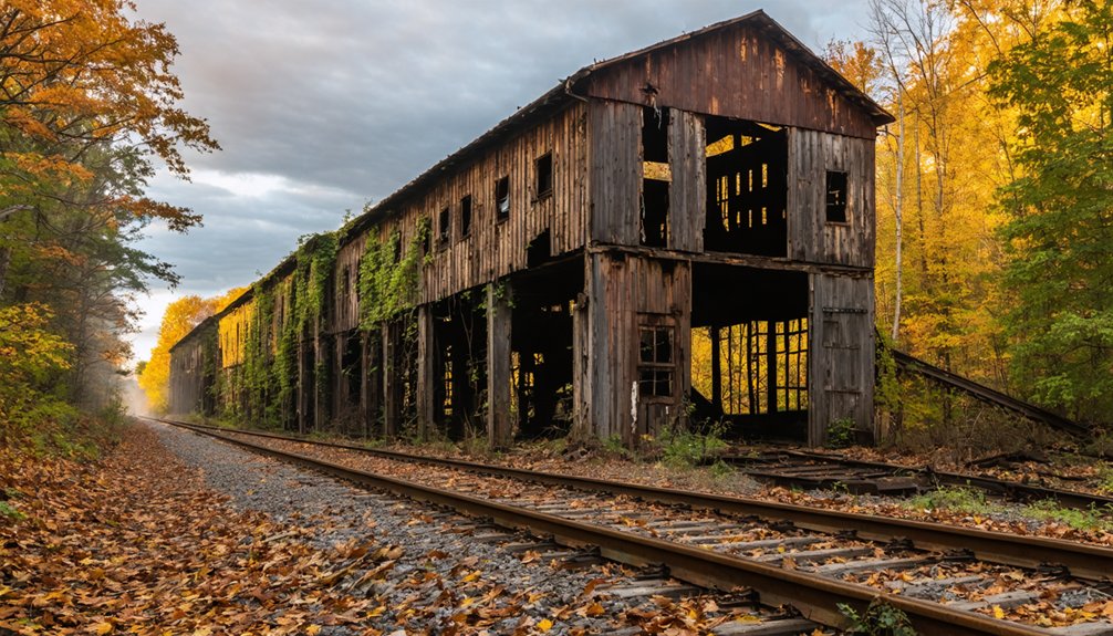
Physical Remnants and Lost Structures
Today’s visitors to Sloan will find only sparse remnants of this once-vibrant railroad town. The most prominent ghost town remnants are the grain elevators and storage silos that stand sentinel along the railroad tracks, marking where this community once thrived.
The history of Snettisham, Alaska is similarly marked by the remnants of a once-thriving industry, with abandoned structures that tell stories of a different time. Much like Sloan, Snettisham bears the marks of change brought by economic shifts and the passage of time. Today, the dilapidated buildings evoke a sense of nostalgia, hinting at the bustling life that once animated this remote Alaskan community.
These agricultural structures, along with one abandoned building nearby, are all that remain visible above ground.
Archaeological studies have revealed more about the site’s prehistoric use than its town-era structures, with excavations uncovering 211 bone fragments from 141 locations in an ancient cemetery.
Unlike other Indiana ghost towns that maintain multiple buildings or visible foundations, Sloan’s physical traces have largely vanished. You won’t find any historical markers or interpretive signs, and the original street grid has disappeared into the landscape.
While some regions are known for their ghost towns in Delaware history, many lack the characteristics that define a traditional ghost town. This absence of remnants and historical context can make it challenging for visitors to appreciate the stories behind these vanished communities. As time marches on, the memories of these places fade, leaving only whispers of their former existence.
Historical Significance in Warren County

Located between Jordan and Steuben Townships in Warren County, Sloan emerged during Indiana’s early settlement period following the displacement of Miami, Kickapoo, and Potawatomi peoples.
Sloan took root in Warren County amid the forced relocation of Miami, Kickapoo, and Potawatomi tribes from their ancestral lands.
The town’s heritage reflects Warren County’s transformation from Native territory to European-American settlement after the county’s 1827 establishment.
You’ll find Sloan’s community dynamics were shaped by:
- Its strategic location less than a mile east of Hedrick
- The presence of a railroad crossing that drove economic growth
- Multiple stores and gathering places that fostered social bonds
- Close ties to Warren County’s agricultural economy
Following the county’s broader patterns of development, Sloan’s significance diminished as populations shifted toward larger towns like Williamsport, though its story remains part of Warren County’s rich historical tapestry.
Frequently Asked Questions
Are There Any Known Photographs of Sloan During Its Peak Years?
Like shadows in time, you won’t find any confirmed vintage images from Sloan’s heyday. Historical archives haven’t revealed peak-era photographs, though you’ll spot a 1995 shot showing its decline.
What Happened to the Original Residents When the Town Was Abandoned?
You’ll find most original residents gradually relocated to nearby towns like Hedrick or West Lebanon seeking jobs after town abandonment. They dispersed throughout Warren County and Indiana following railroad operations’ decline.
Were There Any Notable Accidents or Incidents Along Sloan’s Railroad Crossing?
Through thunder and time, you’ll find no major crossing incidents documented specifically at Sloan’s railroad, though the region’s interurban lines faced safety challenges, including the deadly 1910 Kingsland wreck nearby.
Did Any Famous People Ever Visit or Live in Sloan?
You won’t find any celebrity sightings or famous residents in town records. The community’s historical significance came from its railroad function rather than notable personalities living or visiting there.
What Businesses or Services Existed Besides the General Store and Post Office?
Silence speaks volumes – you won’t find records of saloons, blacksmith shops, or other businesses. Besides the general store and post office, grain silos were the only other documented commercial structures in the area.
References
- https://en.wikipedia.org/wiki/Sloan
- https://www.youtube.com/watch?v=YENGw3D73t4
- https://www.onlyinyourstate.com/trip-ideas/indiana/ghost-town-road-trip-indiana
- https://commons.wikimedia.org/wiki/File:Sloan
- https://en.wikipedia.org/wiki/List_of_ghost_towns_in_Indiana
- https://www.onlyinyourstate.com/experiences/indiana/ghost-towns-in
- https://kids.kiddle.co/List_of_ghost_towns_in_Indiana
- https://www.in.gov/history/for-educators/all-resources-for-educators/resources/underground-railroad/bury-me-in-a-free-land-the-abolitionist-movement-in-indiana-by-gwen-crenshaw/the-underground-railroad/
- https://en.wikipedia.org/wiki/Underground_Railroad_in_Indiana
- https://www.youtube.com/watch?v=thNeSLoEC5o