To plan your ghost town road trip to Ca Ira, Virginia, head to Cumberland County via Route 632 and bring offline maps since cell service disappears fast out here. Founded in 1796 as a tobacco port, Ca Ira collapsed under disease, silted rivers, and Civil War destruction. What’s left includes Grace Episcopal Church and five weathered dwellings. Visit on a weekday morning in spring or fall for the best experience, and there’s much more to uncover ahead.
Key Takeaways
- Ca Ira, Virginia, founded in 1796 in Cumberland County, is a ghost town accessible via Virginia State Route 632, coordinates 37.4917, -78.3361.
- Download offline maps before visiting, as the area lacks cell service, and budget extra time for rural back road navigation.
- Visit in spring or fall for cooler temperatures and clearer visibility; winter reveals hidden foundations as foliage recedes.
- Key landmarks include Grace Episcopal Church, five weathered dwellings along Route 632, and the Ca Ira Fishing Club near a historic pond.
- Extend your road trip by exploring nearby ghost towns Cartersville and Hardware, both shaped by river silting along the James River.
What Is Ca Ira, Virginia’s Ghost Town Story?
Although its name means “It will be fine,” Ca Ira, Virginia’s story is anything but — it’s a ghost town born from broken promises and bad luck. Founded in 1796, this Cumberland County settlement carried abandoned hopes of becoming a major tobacco port along the Willis River.
The historical irony cuts deep: a town named after a French Revolutionary anthem celebrating optimism quietly crumbled under disease, river siltation, and Civil War devastation.
You’ll find almost nothing left today — just Grace Episcopal Church, a handful of modest dwellings, and a fishing club scattered along Route 632.
How To Get To Ca Ira, Virginia
Reaching Ca Ira means traversing Cumberland County‘s quiet back roads, and that journey itself sets the mood for what you’ll find there.
You’ll navigate Virginia State Route 632, locally known as Ca Ira Road, winding through rural landscapes that feel untouched by modern life. The coordinates 37.4917, -78.3361 will guide you precisely to the site, but download offline maps before you leave — cell service disappears once you’re deep into this remote corridor.
That deliberate disconnection from the digital world actually enhances your ghost town exploration, stripping away distraction and sharpening your awareness of the historical significance surrounding every overgrown field and weathered structure.
Give yourself roughly 30 minutes on-site, but budget extra time for the drive itself. These back roads reward patience.
When To Visit Ca Ira for the Best Experience
Ca Ira welcomes visitors year-round, but the season you choose shapes the experience entirely.
Spring and fall offer the best seasons for exploring the overgrown remnants, when cooler temperatures make walking Route 632 comfortable and foliage either frames or reveals the scattered dwellings clearly.
Spring and fall transform Ca Ira’s ruins, cooler air and shifting foliage revealing what summer hides.
Summer brings dense vegetation that swallows structural details, while winter strips the landscape bare, exposing foundations and fence lines you’d otherwise miss.
Check Cumberland County’s local events calendar before heading out, since occasional historical commemorations draw knowledgeable guides to the area.
Weekday visits guarantee solitude, letting the silence of the abandoned village land harder.
Arrive during morning hours when light angles low across Ca Ira Pond, casting shadows that sharpen every remaining structure.
Download offline maps before leaving home — cell service won’t reach you here.
What Survives at Ca Ira Today?
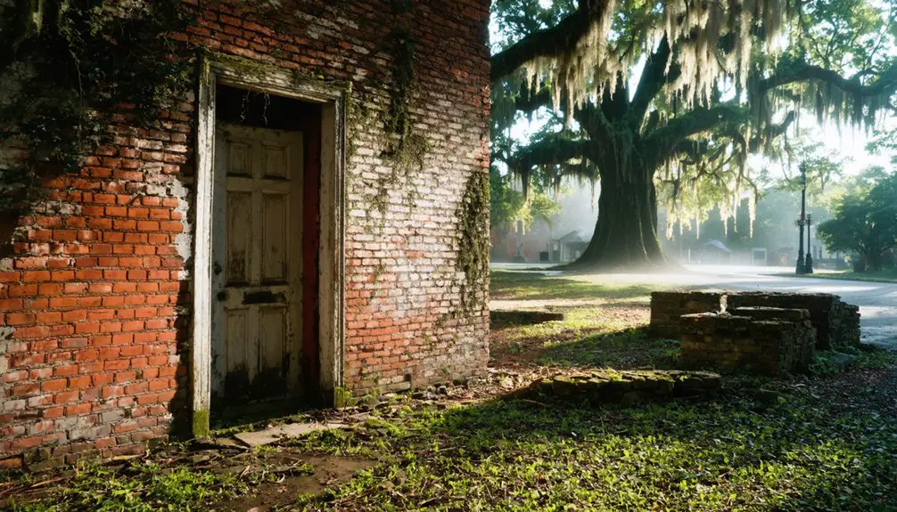
When you arrive at Ca Ira, you’ll find Grace Church, built in the 1840s and listed on the National Register of Historic Places, standing as the town’s most striking survivor.
Scattered along Route 632, you’ll spot roughly five modest dwellings that hint at what was once a planned tobacco port on the Willis River.
The Ca Ira Fishing Club also remains, giving the site an unexpected pulse of activity amid the quiet decay.
Grace Church Still Stands
Only a handful of remnants survive at Ca Ira today, but the most striking is Grace Episcopal Church, built in the 1840s and listed on the National Register of Historic Places.
You’ll find it standing quietly along Route 632, its aged walls carrying both historical significance and ghost stories whispered by those who’ve wandered these grounds.
The designation protects it from demolition, meaning you can still walk up and examine its architecture firsthand.
It’s a rare, tangible link to a community that simply ceased to exist.
When you stand before it, you’re looking at the last credible witness to Ca Ira’s brief, troubled life.
Don’t rush past it — this church is the closest thing to a voice the ghost town still has.
Scattered Dwellings Remain
Beyond the church, five modest dwellings still scatter along Route 632 near Ca Ira Pond, their weathered frames holding on like afterthoughts of a community that never quite took root.
This abandoned architecture tells a quiet story locals still whisper about through local folklore passed down over generations.
As you explore, you’ll notice:
- Deteriorating wood-frame structures sitting close to the pond’s edge
- Overgrown lots where former homes once anchored daily life
- Remnants of fencing marking boundaries nobody enforces anymore
- Subtle foundations barely visible beneath encroaching vegetation
You’re free to roam, but tread carefully — unstable structures demand respect.
These dwellings aren’t restored or maintained; they’re raw, honest fragments of a place that tried and failed.
That authenticity makes Ca Ira worth every mile.
Ca Ira Fishing Club
The Ca Ira Fishing Club stands as perhaps the most unexpected survivor in this quiet ghost town, a functioning landmark amid the decay that gives the site its strange dual identity.
Unlike the crumbling dwellings nearby, the club carries an active fishing history, drawing those who’d rather cast a line than consult a history book.
Ca Ira Pond, once blamed for the disease outbreak that accelerated the town’s collapse, now sustains local wildlife and offers anglers a reason to linger.
You’ll find it oddly grounding — a place where the past and present negotiate a quiet truce.
If you’re exploring Route 632, the club confirms that Ca Ira isn’t entirely lost.
Something functional, something alive, still holds its ground here.
What To Pack for Ca Ira’s Remote, Off-Grid Site
Visiting Ca Ira means stepping into a communication dead zone, so pack accordingly before you leave cell service behind.
These packing essentials and safety tips keep your 30-minute exploration safe and self-sufficient.
- Offline maps – Download Virginia Route 632 and surrounding Cumberland County roads before departure.
- Sturdy footwear – Uneven terrain and unstable structures demand ankle support.
- First aid kit – Wildlife encounters and crumbling surfaces make basic medical supplies non-negotiable.
- Water and snacks – No services exist nearby, so carry your own fuel.
You’re venturing somewhere civilization quietly surrendered.
Respecting that means arriving prepared, leaving nothing behind, and taking only memories from this forgotten stretch of Virginia history.
How To Spend 30 Minutes Exploring Ca Ira

Begin your 30-minute exploration at Grace Church, the 1840s structure standing as Ca Ira’s last dignified remnant and the site’s only National Register-protected building.
From there, walk Route 632 past the handful of modest dwellings still scattered along the road, taking in the quiet that now defines a place once buzzing with tobacco trade ambitions.
Cap your visit at the Ca Ira Fishing Club, a rare living landmark that gives the ghost town’s sparse landscape one last point of human activity to anchor your experience.
Start At Grace Church
Grace Church is your anchor point for exploring Ca Ira, a whitewashed 1840s Episcopal structure that stands as the ghost town‘s most intact survivor and the only building on the National Register of Historic Places.
Its abandoned architecture tells the village’s story better than any marker could.
Start your 30 minutes here by:
- Circling the exterior to examine the 1840s construction details and weathered stonework
- Reading the historical significance markers identifying Ca Ira’s founding and collapse
- Photographing the contrast between the preserved church and the overgrown surroundings
- Orienting yourself toward Route 632, where the remaining five dwellings scatter along the road
You’re standing at the heart of what Virginia once intended as a thriving tobacco port.
It never happened.
Walk Route 632
From the church steps, Route 632 stretches before you as Ca Ira’s last living spine. Walk it slowly.
Five modest dwellings dot the roadside, weathered reminders of a community that tobacco commerce never fully built. The Ca Ira Fishing Club anchors the far end, still functioning where ghost town legends say hundreds once lived and died from pond disease.
You’re walking ground that carries real historical significance — a village named after French Revolutionary hope, swallowed by silting rivers and epidemic.
Every crumbling foundation edge tells that story without a museum required.
Give yourself the full 30 minutes. Download offline maps before arriving since cell service disappears here.
Touch nothing. Take only photographs. Ca Ira’s fragile remains deserve witnesses, not collectors.
Visit The Fishing Club
The Ca Ira Fishing Club marks your final stop — a working landmark that outlasted everything the village once promised. Its club history stretches beyond the ghost town’s collapse, quietly surviving where commerce and ambition couldn’t.
Fishing experiences here connect you to the same pond that once carried disease and drove residents away.
Make your 30 minutes count:
- Observe the structure — note its weathered exterior against the silent landscape
- Walk the pond’s edge — imagine the stagnant water that sealed Ca Ira’s fate
- Read nearby historical markers — they anchor the club within the broader village story
- Photograph the contrast — life continuing where a town died
You’re standing inside a quiet contradiction. The fishing club endures. Ca Ira didn’t.
Other Virginia Ghost Towns Near Ca Ira

While Ca Ira offers a haunting glimpse into Virginia’s forgotten past, Cumberland County and its surrounding region hide several other ghost towns worth tracking down on your road trip.
Nearby Cartersville and Hardware, both along the James River, deliver rich ghost town experiences shaped by similar forces — river silting, economic collapse, and Civil War devastation.
You’ll find crumbling foundations, abandoned churches, and overgrown cemeteries that reward curious explorers willing to venture off paved roads.
Historical preservation efforts vary widely across these sites, so research each location before you arrive. Some offer marked trails and signage while others remain completely raw and undocumented.
Together, these forgotten communities paint a vivid portrait of Virginia’s rural collapse, making your road trip far more than a single-stop excursion.
Frequently Asked Questions
Is There an Entrance Fee to Visit Ca Ira Ghost Town?
No entry fee guards Ca Ira’s ghost town history — nature’s already claimed it! You’ll explore visitor experiences freely, roaming crumbling remnants along Route 632 without paying a dime. Just bring curiosity and offline maps!
Can You Camp Overnight Near Ca Ira, Virginia?
No designated campsite exists at Ca Ira, so you’ll need to follow local camping regulations and explore nearby attractions for overnight options. Check Cumberland County parks—they’ll satisfy your freedom-seeking spirit beautifully.
Who Owns the Land Where Ca Ira Once Stood?
The knowledge doesn’t specify who owns the land where Ca Ira once stood. You’ll want to research Cumberland County property records to uncover land ownership details and honor this site’s historical significance before you visit.
Are Guided Tours of Ca Ira Available for Visitors?
You’ll begin a self-guided exploration of Ca Ira’s historical significance, as no formal tours exist. You’re free to roam independently, spending roughly 30 minutes discovering the ghostly remnants scattered along Route 632 at your own pace.
What Disease Outbreak Contributed to Ca Ira’s Population Decline?
You’ll find that stagnant water from Ca Ira Pond sparked a devastating disease outbreak, carrying historical significance as it decimated the local population. This disease impact sealed the town’s tragic fate, crushing its once-hopeful spirit forever.
References
- https://www.visitcalifornia.com/road-trips/ghost-towns/
- https://en.wikipedia.org/wiki/Ca_Ira
- https://www.visitcalifornia.com/now/california-ghost-towns-road-trip/
- https://ghost-towns.close-to-me.com/states/virginia/ca-ira-va/
- https://www.explore.com/1709921/how-to-visit-best-california-ghost-towns-in-one-trip/
- https://www.youtube.com/watch?v=frhQyls3jto
- https://www.onlyinyourstate.com/trip-ideas/virginia/road-trip-through-va-ghost-towns
- https://ghost-towns.close-to-me.com/states/virginia/
- https://myfamilytravels.com/explore-californias-forgotten-towns-with-these-eerie-road-adventures/
- https://www.barbaranusselphotography.com/blog/2017/4/20/wildflowers-and-ghost-towns-a-road-trip-through-central-california