Planning a ghost town road trip to Senterfitt, Texas means heading to western Lampasas County, roughly 3½ miles west of Lometa along Salt Creek. You’ll find a weathered cemetery, crumbling foundations, and a historical marker telling the story of a cattle community that thrived until the 1885 railroad bypassed it entirely. Spring and fall offer the best visiting conditions. Stick around, because there’s much more to uncover about Senterfitt’s rise, fall, and forgotten neighbors.
Key Takeaways
- Senterfitt, Texas, sits along Salt Creek in western Lampasas County, roughly 3½ miles west of Lometa, accessible via Highway 581.
- The Senterfitt Cemetery serves as the primary landmark, featuring weathered grave markers, visible building foundations, and an informative historical marker.
- Spring and fall offer the best visiting conditions, with spring providing blooms and extended daylight, while fall creates a haunting ghost town atmosphere.
- Visitors should stay on visible paths, avoid removing artifacts, and minimize contact with foundations to protect this irreplaceable historical site.
- Nearby ghost towns like Bend, Montvale, and San Saba County settlements can be combined into a fuller central Texas road trip itinerary.
What’s Left to See at Senterfitt, Texas
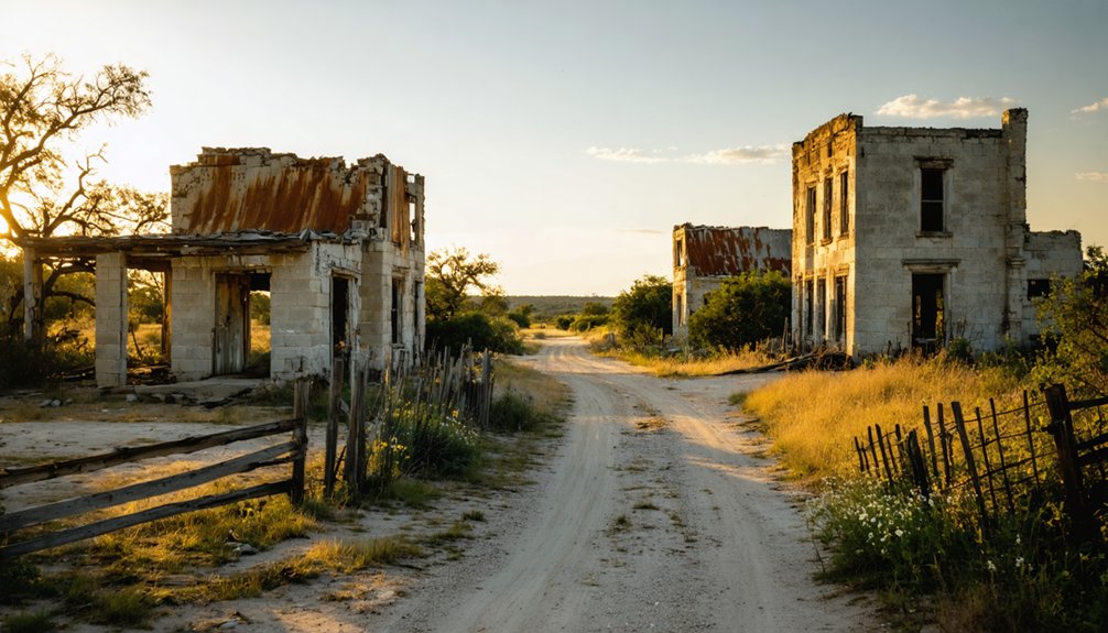
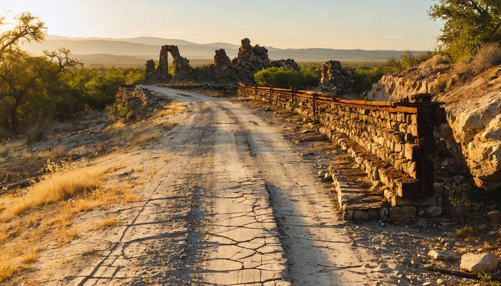
When you arrive at the site of Senterfitt, Texas, you’ll find a quiet stretch of land along Salt Creek that tells its story through what remains — a cemetery, scattered building foundations, and a historical marker that anchors the town’s memory to the present.
The Senterfitt remnants aren’t dramatic, but they’re honest. You’ll walk ground where roughly 150 people once built lives around a stage line stop before the railroad rewrote everything in 1885.
The remnants aren’t dramatic, but they’re honest — 150 lives built here before the railroad erased everything.
The historical significance here isn’t about grandeur — it’s about recognizing how quickly a thriving crossroads community can vanish when commerce shifts direction.
Explore the cemetery, study the foundations, and read the marker. Together, they hand you the full story without requiring anything more than your attention.
How Senterfitt Went From Cattle Town to Ghost Town
When you look at Senterfitt’s origins, you’ll find a thriving cattle town that took root in the 1860s, built around the legacy of cattle king Reuben S. Senterfitt and sustained by a busy stage line running between Lampasas and San Saba.
At its peak, the community supported around 150 residents, a post office, and a school — all the hallmarks of a town with a promising future.
But in 1885, the railroad extended to nearby Montvale (soon renamed Lometa), rerouting commerce just three miles away and pulling the economic rug right out from under Senterfitt.
Senterfitt’s Cattle Town Origins
Before the railroad reshaped the Texas frontier, Senterfitt thrived as a cattle town built on the ambitions of one man.
Reuben S. Senterfitt dominated the local cattle industry during the 1850s, and the community that bore his name grew up around his influence.
Railroad Bypass Triggers Decline
The railroad’s arrival in 1885 didn’t bring prosperity to Senterfitt—it delivered a death sentence. When the tracks bypassed the community entirely, stopping three miles east at Montvale (soon renamed Lometa), ghost town economics took hold almost immediately.
Commerce followed the iron rails, as it always did across the Texas frontier. You can almost picture it: merchants loading wagons, families relocating, the stage line falling silent. The post office shuttered. The school closed.
Within months, a thriving crossroads community of 150 residents practically evaporated.
Understanding this railroad impact helps you appreciate what you’ll discover when you visit today. The freedom Senterfitt once represented—independent trade routes, self-sufficient community life—vanished the moment those tracks chose a different path.
Where Exactly Is Senterfitt Located?
You’ll find Senterfitt in western Lampasas County, Texas, sitting along Salt Creek just west of Ranch Road 581.
The ghost town rests 3½ miles west of Lometa, the very community that replaced it after the railroad arrived in 1885.
To reach it, you’ll follow Highway 581 between Bend and Lometa, using the Senterfitt Cemetery as your primary landmark once you’re in the area.
Lampasas County Exact Location
Nestled in western Lampasas County, Senterfitt sits just west of Ranch Road 581, roughly 3½ miles from the small town of Lometa.
Understanding Senterfitt history means knowing exactly where to look when you’re traversing this remote stretch of Texas. Ghost towns don’t announce themselves, so use these landmarks:
- Highway 581 between Bend and Lometa marks your primary route
- Salt Creek runs alongside the original townsite
- Ranch Road 581 positions you just east of the ruins
- Senterfitt Cemetery serves as your most reliable on-ground marker
You’re venturing into open Texas hill country here, so download offline maps before leaving.
The site rewards explorers who arrive prepared, giving you the freedom to roam without second-guessing your bearings.
Nearby Landmarks And Roads
Finding Senterfitt requires just a handful of reliable reference points, all clustered within a short stretch of western Lampasas County. Ranch Road 581 runs directly past the site, making road accessibility straightforward for any traveler heading between Bend and Lometa.
You’ll find the ghost town sitting just west of that road, roughly 3½ miles from Lometa itself.
Salt Creek marks the natural geography surrounding the area, grounding you in the landscape as you arrive. For landmark significance, the Senterfitt Cemetery stands as your clearest navigational anchor — it’s visible and well-documented, unlike the scattered foundations nearby.
If you’re driving Highway 581, watch for the cemetery first. Everything else radiates outward from that single, enduring point where the community once thrived and quietly disappeared.
Distance From Lometa
Three and a half miles west of Lometa, Senterfitt sits just past Ranch Road 581 along the Salt Creek corridor in western Lampasas County.
When you’re planning your travel routes, these distance metrics help you navigate efficiently:
- Start in Lometa — your natural base for the trip
- Head west on Highway 581 — your primary corridor toward Bend
- Watch for Ranch Road 581 — Senterfitt appears just west of this junction
- Use Senterfitt Cemetery — the most visible landmark confirming your arrival
You won’t find street signs pointing the way, so knowing these exact distances matters.
The 3½-mile stretch from Lometa moves quickly, dropping you into quiet ranch country where the ghost town’s foundations and historical marker await your exploration.
How to Get to Senterfitt From Lometa

Getting to Senterfitt from Lometa takes only a few minutes, but it’s a drive that carries you back through more than a century of Texas history.
Head west on Ranch Road 581, one of the scenic routes connecting Lometa to the surrounding Hill Country landscape. You’ll travel roughly 3½ miles before reaching the site, situated just west of the road along Salt Creek.
Head west on Ranch Road 581 for roughly 3½ miles — the site waits quietly along Salt Creek.
Keep your eyes open for local wildlife along the way — deer and native birds frequently move through this quiet stretch of central Texas terrain.
The drive itself is short, unhurried, and completely on your own terms. No crowds, no toll roads, just open land and the freedom to explore a piece of history that most people never know exists.
The Senterfitt Cemetery: Graves, Grounds, and What Survives
The Senterfitt Cemetery stands as the most tangible remnant of a community that the railroad erased from the map in 1885. Its cemetery significance extends beyond headstones — it’s your clearest window into who actually built this place.
When you walk the grounds, you’ll notice:
- Weathered grave markers dating to the town’s active period
- Visible foundations of structures scattered nearby
- A historical marker explaining the community’s origins and collapse
- Maintained grounds that reflect ongoing historical preservation efforts
You’re free to explore at your own pace. Bring water, wear sturdy shoes, and give yourself time to read each marker carefully.
Spring and late fall offer the most comfortable conditions for walking the site without battling Texas heat.
Spring vs. Fall: When Should You Visit Senterfitt?

Timing your visit to Senterfitt can make a real difference in what you experience at this remote ghost town.
In spring, you’ll find milder temperatures, greener surroundings, and firmer ground conditions that make traversing the cemetery and scattered ruins far more comfortable.
Fall brings its own quiet appeal, stripping the landscape bare and casting a stark, haunting atmosphere that feels perfectly suited to exploring a forgotten 19th-century community.
Spring’s Ideal Visiting Conditions
When planning your visit to Senterfitt, spring edges out fall as the superior season for ghost town exploration. Mild temperatures and spring blooms transform the Salt Creek landscape, making the site’s historical significance more accessible and visually striking.
You’ll navigate the terrain around Ranch Road 581 with greater ease, and the cemetery’s weathered markers stand out beautifully against fresh greenery.
Spring offers distinct advantages:
- Comfortable temperatures keep outdoor exploration manageable
- Wildflowers enhance photography of ruins and the cemetery
- Firm ground conditions improve access to building foundations
- Extended daylight hours give you more time to examine the site
You’ll leave with a deeper appreciation for what Senterfitt once was before the 1885 railroad bypassed it into oblivion.
Fall’s Ghost Town Appeal
Fall strips the Salt Creek landscape bare, and that stark clarity works in your favor when you’re hunting for the ghost town remnants of Senterfitt. As fall foliage thins out, foundation outlines and structural remains become far easier to spot against the exposed terrain. You’ll navigate the site with fewer obstructions blocking your sightlines.
Late fall also carries an atmospheric quality that spring simply can’t match. The shorter days, cooler temperatures, and quieter surroundings amplify the eerie silence of an abandoned community. If ghost stories fuel your curiosity about places like Senterfitt, autumn delivers the right mood for contemplating the lives that vanished here after 1885.
Ground conditions typically remain firm in fall, making the Senterfitt Cemetery and surrounding ruins comfortably accessible without spring’s unpredictable mud.
Which Ghost Towns Near Senterfitt Are Worth the Detour?
Once you’ve walked the quiet grounds of Senterfitt, the surrounding region of western Lampasas County pulls you deeper into Texas’s ghost town trail.
These hidden treasures reward curious travelers willing to wander off the main roads. Several nearby ghost towns deserve your attention:
- Lometa – Senterfitt’s direct successor, offering historical context about railroad-era growth.
- Montvale – Lometa’s original name, with roots tracing the 1885 railroad arrival.
- Bend – A scenic Salt Creek-area community with its own faded past.
- San Saba County settlements – Crossroads communities sharing Senterfitt’s mid-19th-century origin story.
Each stop deepens your understanding of why these ghost towns rose and fell.
Pack water, charge your camera, and let western Texas rewrite your definition of freedom.
How the Railroad That Killed Senterfitt Built Lometa
The same iron rails that silenced Senterfitt breathed life into a brand-new town just three miles away. When the railroad arrived in 1885, it bypassed Senterfitt entirely, redirecting commerce toward a settlement then called Montvale.
That railroad impact transformed Montvale almost overnight, prompting a name change to Lometa and sparking rapid Lometa development that drew merchants, settlers, and opportunity seekers away from Senterfitt’s dusty streets.
As you trace this history on your road trip, consider what that moment meant — one community’s death funded another’s birth.
Lometa even gained its own narrow-gauge railroad connecting cedar-cutting operations to broader markets, sustaining the region well into the 20th century.
Senterfitt’s loss wasn’t random; it was economic gravity pulling everything toward the nearest set of tracks.
How to Respect and Preserve Texas Ghost Town Sites
Visiting a place like Senterfitt means stepping into something fragile — a community frozen in its final chapter, where every crumbling foundation and weathered gravestone represents a life once lived.
Ghost town preservation depends entirely on visitors who understand historical site etiquette. Follow these four principles:
Ghost towns survive only when visitors arrive as stewards — treating every artifact, stone, and shadow as irreplaceable.
- Take nothing — artifacts, stones, and debris belong to the site
- Touch foundations minimally — weathered structures collapse faster than you’d expect
- Photograph everything, disturb nothing — your camera preserves history better than your hands
- Stay on visible paths — unmarked graves exist beyond cemetery boundaries
You’re not just a visitor here — you’re a temporary steward of something irreplaceable.
Senterfitt survived railroad abandonment and a century of Texas weather. Don’t let careless curiosity finish what time couldn’t.
What Lometa’s Railroad History Adds to a Senterfitt Day Trip
Lometa exists because Senterfitt died. When the railroad arrived in 1885, commerce abandoned the old stage stop and rushed three miles east to Montvale, which quickly renamed itself Lometa. That railroad impact reshaped the entire region overnight, redirecting trade, people, and opportunity away from Salt Creek’s crossroads.
Pairing Senterfitt with a stop through Lometa transforms your day trip into a complete regional story. You’ll see both sides of the same economic coin — the ghost town the railroad killed and the community it created.
Explore Lometa’s heritage by noting its early railroad-era buildings and the legacy of the narrow-gauge Scholten line that once hauled cedar posts through the area. Together, these two stops give you the full, unfiltered picture of 19th-century Texas ambition.
Frequently Asked Questions
Was Reuben S. Senterfitt Buried in the Senterfitt Cemetery?
Ironically, Senterfitt history doesn’t confirm Reuben S. Senterfitt’s burial there. You’ll find cemetery legends surrounding this ghost town fascinating, but records don’t verify the cattle king’s final resting place within those historic grounds.
Can You Camp Overnight Near the Senterfitt Ghost Town Site?
The knowledge doesn’t confirm overnight camping options near Senterfitt, so you’ll want to research local camping regulations beforehand. Nearby attractions like the cemetery and ruins make it worth finding a suitable campsite close by!
Is There an Admission Fee to Visit Senterfitt Cemetery?
There’s no admission fee! Admission details are simple — you’re free to explore. With over 150 former residents, the Cemetery history spans back to the 1860s, making your visit both historically rich and completely accessible.
Are Guided Tours of Senterfitt Available Through Local Historical Societies?
No official guided history tours exist for Senterfitt, but you’ll discover local legends by connecting with Lampasas County historical societies. They’re passionate about sharing the region’s rich past and can enhance your ghost town exploration tremendously.
What Other Ghost Towns Existed Along the Original Lampasas to San Saba Route?
Like forgotten chapters in a book, the knowledge doesn’t specify other ghost towns along that route. You’ll find Senterfitt’s abandoned buildings hold historical significance, but exploring local Texas archives can uncover neighboring lost communities awaiting your discovery.
References
- https://www.ghosttowns.com/states/tx/senterfitt.html
- https://www.tshaonline.org/handbook/entries/senterfitt-tx
- https://www.lampasas.org/640/History
- https://en.wikipedia.org/wiki/List_of_ghost_towns_in_Texas
- https://www.hmdb.org/m.asp?m=175313
- https://www.texasalmanac.com/places/senterfitt
- https://texashistory.unt.edu/ark:/67531/metapth61101/


