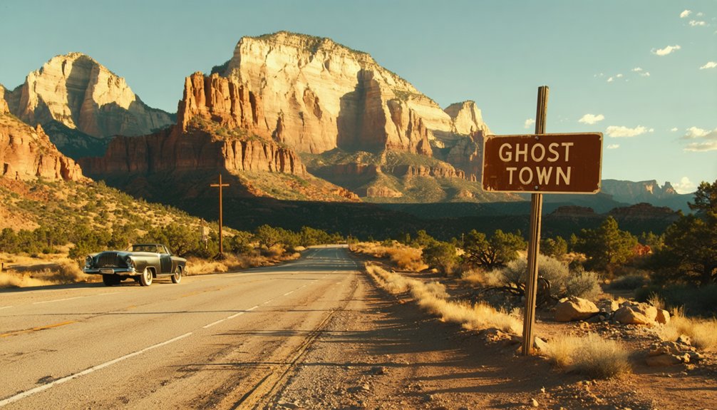
To plan your ghost town road trip to Argyle, Utah, anchor your route around Grafton, Frisco, Thistle, and Latuda before heading into Argyle Canyon where Nine Mile Canyon crosses the old stage trails. You’ll need a high-clearance vehicle, printed maps, and extra water since cell service disappears fast out here. Spread the journey across three days to truly walk these ruins rather than just pass through. There’s far more to uncover ahead.
Key Takeaways
- Argyle Canyon sits at the junction of Argyle and Nine Mile Canyons, requiring navigation skills, offline maps, and a high-clearance vehicle for access.
- Nearby ghost towns include Grafton, Frisco, Thistle, and Latuda, each offering unique historical insights spanning Mormon pioneer, mining, and railroad eras.
- Spread the trip across three days, anchoring around Grafton and Frisco first, then Thistle and Latuda, finishing at Harper and Argyle Canyon.
- Visit during spring or fall for the best road conditions, photography lighting, and manageable temperatures across remote, unpaved desert routes.
- Pack printed maps, a compass, ample water, food, camera gear, and emergency vehicle supplies, as cell service is largely unavailable throughout the region.
Where Exactly Is Argyle Canyon, Utah?
Tucked into the rugged high desert of eastern Utah, Argyle Canyon sits at the intersection of Argyle and Nine Mile Canyons, a remote stretch of landscape that once hummed with stagecoach traffic and ranching life.
This geographic location isn’t marked on many tourist maps, which makes finding it feel like a genuine discovery. Argyle Canyon’s historical significance runs deep — it served as a crucial stage station crossroads, connecting travelers moving through Utah’s wild interior.
You’ll need a sense of direction and a spirit of independence to reach it. The surrounding canyon walls and open terrain reward those willing to venture off the beaten path.
If you’re building a ghost town road trip, Argyle Canyon deserves a prominent place on your route.
What Makes Argyle Canyon Worth the Drive?
When you roll into Argyle Canyon, you’re not just chasing scenery—you’re tracing the wheel ruts of stagecoaches that once connected isolated ranching communities across Utah’s high desert.
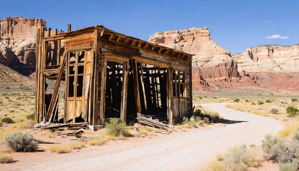
The remnants of Harper, a former stage station positioned at the intersection of Argyle and Nine Mile Canyons, give you a rare, tangible link to the territory’s working past.
The access road itself becomes part of the experience, pulling you through raw canyon terrain that filters out the casual visitor and rewards the determined explorer.
Argyle Canyon’s Unique Appeal
Stretching through the high desert of eastern Utah, Argyle Canyon draws travelers with a rare combination of rugged scenery and layered frontier history.
You’ll find yourself traversing terrain that once supported stage stations, ranching operations, and frontier commerce at the crossroads of Argyle and Nine Mile Canyons.
It’s the kind of place where ghost town photography feels genuinely rewarding — crumbling remnants sit against dramatic canyon walls, giving every frame authentic depth and character.
Harper, the former stage station nearby, represents the area’s commitment to historical preservation without sanitizing the rawness that makes these sites compelling.
You’re not visiting a museum — you’re moving through living history on your own terms, at your own pace, with nothing but open road ahead.
Historic Stage Station Remnants
Harper once served as a critical waypoint where stage coaches paused, horses were swapped, and frontier commerce briefly flourished at the intersection of Argyle and Nine Mile Canyons.
Today, you’ll find remnants that speak quietly but powerfully about the town’s historical significance along these canyon routes.
The surviving stage station architecture tells a raw, unfiltered story of westward movement — structures built for utility, not permanence, yet somehow enduring.
You’re standing where travelers once rested before pushing deeper into Utah’s rugged interior. That context transforms scattered ruins into something genuinely compelling.
Harper doesn’t offer dramatic restoration or guided tours. Instead, it rewards your curiosity with authenticity.
If you value discovering places that history nearly swallowed whole, this forgotten canyon crossroads delivers exactly that kind of unscripted, boundary-free exploration.
Scenic Desert Road Access
The drive into Argyle Canyon doesn’t just deliver you to Harper — it earns your arrival. You’ll navigate unpaved roads cutting through raw desert landscapes that haven’t changed much since stagecoaches rattled through here carrying mail and passengers across southern Utah.
Every mile strips away modern noise and replaces it with geological honesty — sandstone walls, open sky, and silence that feels intentional.
This route carries real historical significance. You’re tracing the same corridor that once connected isolated ranching communities to the outside world.
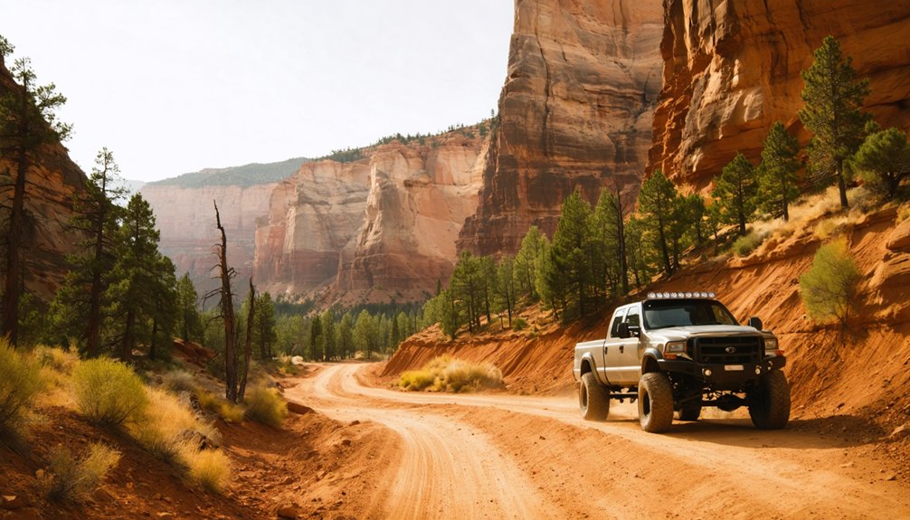
No cell service, no guardrails, no crowds telling you where to look. Bring a high-clearance vehicle, a paper map, and the willingness to move at the canyon’s pace.
The freedom you’re after starts the moment pavement ends.
Harper Ghost Town: Argyle Canyon’s Stage Station History
As you roll into Harper, you’re stepping onto ground that once buzzed with the energy of stagecoaches and cattle drives at the crossroads of Argyle and Nine Mile Canyons.
This former stage station served as a crucial hub for ranchers and travelers pushing through the rugged Utah backcountry, and its remnants still whisper that hardscrabble history.
You’ll find Harper’s legacy woven tightly into Argyle Canyon’s ranching heritage, where the land itself tells the story of a community built on grit, movement, and survival.
Harper’s Stage Station Origins
Nestled at the intersection of Argyle and Nine Mile Canyons, Harper once served as an essential stage station and ranching hub in the rugged Utah backcountry.
This forgotten outpost connected travelers crossing demanding canyon terrain, offering rest, supplies, and fresh horses before the next grueling stretch.
Harper history reveals a community built entirely on necessity — survival demanded it. As a stage station, it kept commerce and communication alive across isolated high desert routes that most modern travelers wouldn’t dare navigate without GPS.
Today, you’ll find remnants of that self-reliant spirit scattered across the landscape. Exploring Harper means stepping into a world where freedom wasn’t romanticized — it was earned daily against unforgiving geography.
It’s raw, authentic Utah history waiting for those willing to seek it out.
Argyle Canyon’s Ranching Legacy
Beyond the stage station’s weathered walls, Argyle Canyon’s ranching legacy runs just as deep. Hardy settlers carved working spreads into this rugged terrain, raising cattle where canyon walls channeled both water and wind.
Their ranching heritage shaped the landscape long after the stages stopped rolling through.
You’ll feel that history when you walk the canyon’s edges, reading the land like the ranchers once did. Ghost town legends here aren’t just about abandoned buildings—they’re about families who refused easy living and built something lasting in a demanding country.
Argyle Canyon rewards the curious traveler willing to look beyond the obvious. Bring your sense of adventure, study the terrain, and let the silence tell you what the history books can’t fully capture.
Grafton, Thistle, and Frisco: Ghost Towns Near Argyle Canyon
While Argyle Canyon‘s Harper ghost town anchors your southern Utah adventure, three other abandoned settlements deserve a spot on your itinerary: Grafton, Thistle, and Frisco.
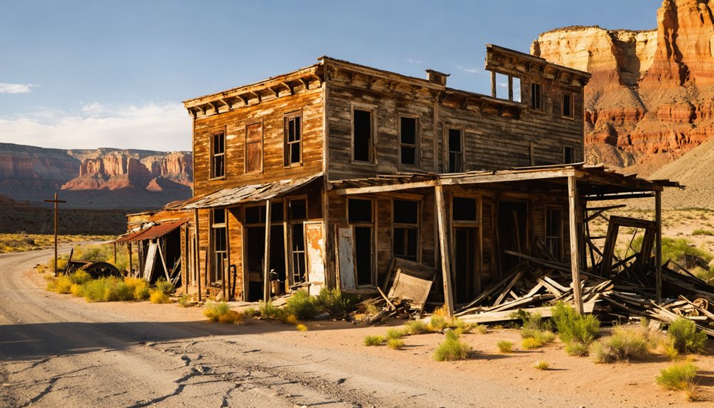
Grafton history runs deep — Mormon pioneers founded it in 1859, and today’s ghost town preservation efforts by the Grafton Heritage Partnership have restored five homesteads and a schoolhouse since 1997.
Butch Cassidy filmed here, making it the West’s most photographed ghost town.
Thistle exploration reveals a railroad town swallowed by a catastrophic 1983 landslide, a place that once housed 600 residents before nature reclaimed it.
Frisco photography delivers dramatic desert ruins from a booming mining settlement turned silent ghost town.
Together, these three sites transform your road trip into an unforgettable journey through Utah’s raw, abandoned history.
How to Build a Southern Utah Ghost Town Itinerary
To build a southern Utah ghost town itinerary, you’ll want to anchor your route around Grafton and Frisco, then layer in stops like Thistle and Latuda as the miles allow.
With over 14 hours of total driving across 10+ towns, you’re better off spreading the trip across two days, reserving time to actually walk the sites rather than just pass through.
Pack a map and compass, load coordinates for remote locations, and bring a high-clearance vehicle — these roads don’t forgive shortcuts.
Planning Your Route Efficiently
Planning a southern Utah ghost town road trip takes more than just plugging addresses into a GPS — it demands strategy, flexibility, and a healthy respect for unpaved roads.
With over 14 hours of total driving across 10+ towns, you’ll want to spread this adventure across two days minimum.
Group towns geographically to avoid backtracking. Start with Grafton near Zion, where southern Utah geology creates breathtaking backdrops for ghost town photography, then push northeast toward Thistle, Latuda, and Frisco.
Prioritize a high-clearance vehicle — dirt roads like Smithsonian Butte Byway punish unprepared drivers.
Download offline maps before you lose cell service. Check weather forecasts obsessively; flash floods don’t negotiate.
Respect private property boundaries clearly marked at each site, and carry water, a compass, and extra fuel.
Essential Road Trip Stops
Building a southern Utah ghost town itinerary means anchoring your route around two essential starting points: Grafton and Frisco. Both reward ghost town photography and carry deep local folklore worth absorbing before you venture further.
From there, expand your route strategically:
- Grafton – Mormon pioneer settlement near Zion; explore five restored homesteads and a haunting cemetery.
- Frisco – Remote silver boomtown ruins with beehive kilns standing against open desert sky.
- Thistle – Railroad town swallowed by a 1983 landslide; eerie and visually striking.
- Latuda – Abandoned coal mining settlement near Helper; closed 1967, frozen in industrial silence.
Stack these stops across two days. Bring a high-clearance vehicle, paper maps, and enough freedom to wander off-schedule.
Multi-Day Itinerary Tips
Because southern Utah’s ghost towns sprawl across hundreds of miles of canyon country, you’ll need at least two days to do the route justice—ideally three if you want breathing room to explore rather than just check boxes.
Start with Grafton and Frisco on day one—both reward serious ghost town photography and reflect genuine historical preservation efforts.
On day two, push toward Thistle and Latuda, where railroad and mining histories collide dramatically.
Reserve day three for Harper and the canyon country surrounding Argyle, where fewer visitors mean quieter discoveries.
Camp where you can, stay in St. George or Cedar City when you can’t, and build buffer time for dirt roads that punish schedules.
The towns aren’t going anywhere—but daylight is.
Best Time of Year to Visit Argyle Canyon
Spring and fall are your best bets for exploring Argyle Canyon, when mild temperatures make the rugged terrain far more forgiving than the scorching summer heat or unpredictable winter road conditions.
Follow these best season travel tips for a rewarding journey:
- Spring (March–May): Wildflowers bloom across canyon walls; roads dry from winter runoff.
- Summer (June–August): Extreme heat demands early morning starts and extra water.
- Fall (September–November): Golden light transforms historic remnants into stunning photography.
- Winter (December–February): Dirt roads become treacherous; high-clearance vehicles essential.
You’re chasing history here — the echoes of stage stations and ranching life deserve proper conditions.
Don’t let poor timing cut your adventure short.
Do You Need a High-Clearance Vehicle for Argyle Canyon Roads?
Whether you’re rolling toward Argyle Canyon in a sedan or a lifted 4×4, the road will quickly make its expectations clear.
Canyon road conditions here aren’t paved promises — they’re rutted, unpredictable, and shaped by weather, runoff, and decades of raw use. High clearance vehicles aren’t just recommended; they’re your passport to reaching Harper and the surrounding ghost town remnants without bottoming out or turning back defeated.
A standard car might manage dry stretches, but one rain event transforms these dirt roads into something unforgiving. Before you go, check recent conditions, study your route, and travel with a paper map — cell service won’t save you out here.
Come prepared, and the canyon rewards you with history few bother to reach.
What to Pack for Visiting Argyle Canyon and Nearby Ghost Towns
Packing for Argyle Canyon isn’t just about comfort — it’s about survival strategy in a landscape that doesn’t negotiate. Cell service vanishes. Roads turn treacherous. Ghost towns like Harper reward the prepared and punish the careless.
Your packing essentials:
- Navigation tools — printed maps and a compass; GPS fails here
- Water and food — carry more than you think you’ll need for 14+ hours of driving
- Camera gear — ghost town photography demands wide-angle lenses and extra batteries for capturing abandoned stage stations
- High-clearance vehicle kit — tire repair tools, tow straps, emergency supplies
These former Mormon settlements and ranching outposts don’t offer second chances. Pack deliberately, move confidently, and let Utah’s raw desert history reward your preparation.
Is Zion National Park Worth Adding to Your Argyle Canyon Trip?
Once your gear’s loaded and your route mapped, the question isn’t whether to visit Zion National Park — it’s whether you can justify skipping it.
Once the route is mapped and the gear is loaded, the only question left is why you’d skip Zion.
Grafton sits just south of Zion’s boundary, meaning you’re already there. The Zion Views alone reward the detour — towering sandstone walls carved by millions of years of geological force.
Canyon Trails weave through landscapes that make ghost town ruins feel even more haunting by contrast. You’re moving between two versions of Utah’s story: one shaped by ancient geology, one by human ambition and failure. Both deserve your time.
Adding Zion doesn’t bloat your itinerary — it deepens it. When you’re this close to something extraordinary, stopping makes more sense than driving past.
Combining Argyle Canyon With Grafton and Nine Mile Canyon
Grafton, Argyle Canyon, and Nine Mile Canyon don’t just share a state — they share a story about people who carved lives into unforgiving terrain and eventually lost the fight.
Linking these ghost towns creates a raw, honest road trip through Utah’s forgotten corners.
Plan your route around four anchors:
- Start at Grafton, Utah’s most photographed ghost town, near Zion.
- Drive Smithsonian Butte Backcountry Byway for dramatic desert change.
- Push northeast toward Argyle Canyon’s stage station remnants at Nine Mile Canyon.
- Follow Nine Mile Canyon’s petroglyphs and ranching ruins for a final stretch.
You’re not just connecting dots — you’re tracing collapse.
Each stop deepens your understanding of how completely the West swallowed these communities whole.
Frequently Asked Questions
Are There Entrance Fees or Permits Required to Visit Harper Ghost Town?
You don’t need permits or fees to explore Harper Ghost Town — entrance requirements are minimal, keeping your adventure free. Respecting historic preservation guarantees this forgotten stage station survives for fellow freedom-seeking wanderers who follow your dusty trail.
Can You Camp Overnight Near Argyle Canyon or Harper Ghost Town?
The knowledge doesn’t confirm camping regulations near Argyle Canyon or Harper’s ghost town amenities. You’ll want to research Bureau of Land Management guidelines beforehand—embrace that adventurous freedom responsibly and guarantee you’re pitching camp on legal, designated land.
Is Argyle Canyon Accessible to Visitors With Mobility Limitations or Disabilities?
The knowledge doesn’t confirm wheelchair access details, but trail conditions at Argyle Canyon’s rugged dirt roads challenge mobility. You’ll want to research beforehand, as unpaved terrain may limit accessibility for visitors with disabilities.
Are Pets Allowed When Exploring Harper Ghost Town and Argyle Canyon?
The knowledge doesn’t confirm pet-friendly policies for Harper or Argyle Canyon, so research beforehand. If you bring your dog, practice ghost town etiquette—keep them leashed, respecting these historically-grounded, freedom-filled remnants of the past.
How Long Should Visitors Budget for Exploring Harper Ghost Town Completely?
Like peeling back layers of time, you’ll want to budget 2–3 hours to absorb Harper’s ghost town history fully. Pack your exploration tips—wander the stage station remnants, soak in Argyle Canyon’s rugged freedom, and let curiosity guide you.
References
- https://www.youtube.com/watch?v=JDIhYM_i-vU
- https://myhikes.org/trails/grafton-ghost-town
- https://www.onlyinyourstate.com/trip-ideas/utah/road-trip-ut-ghost-towns
- https://www.legendsofamerica.com/harper-utah/
- https://www.deseret.com/utah/2023/1/21/23549285/utah-ghost-towns-mormon-history/
- https://www.visitutah.com/things-to-do/history-culture/ghost-towns


