Planning a ghost town road trip to Chispa, Texas means committing to 56 unpaved miles of raw Chihuahuan Desert solitude. You’ll leave Van Horn heading south on Highway 90, then push through rugged Sierra Vieja Mountain terrain on Chispa Road. Bring extra fuel, water, and a high-clearance vehicle because cell service disappears fast. Visit between March and May or September and November for the best conditions. There’s far more to uncover about making this unforgettable journey count.
Key Takeaways
- Chispa, Texas offers remote solitude, rich mining history, and rugged Chihuahuan Desert landscapes free from commercial distractions.
- Drive from Van Horn via Highway 90 south for 30 miles, then take Chispa Road for 56 unpaved miles.
- A high-clearance, rugged vehicle is essential; road conditions vary significantly depending on recent weather.
- Visit between March to May or September to November for mild temperatures and optimal road conditions.
- Pack spare tires, extra fuel, ample water, a first-aid kit, and a satellite communicator for emergencies.
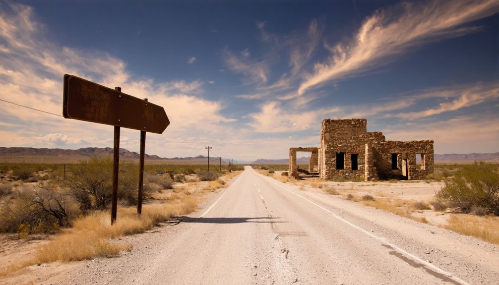
What Makes Chispa, Texas Worth the Drive?
If you’re chasing the kind of solitude that most travelers never find, Chispa, Texas delivers it in spades.
This forgotten railroad settlement carries real Chispa history — a past rooted in mining significance, when the surrounding Chihuahuan Desert fueled West Texas’s economic ambitions.
Today, silence has replaced the activity, but the landscape hasn’t lost its power.
The bustle has faded, but the desert’s quiet intensity still commands every bit of your attention.
You’ll share the road with desert wildlife, from roadrunners to mule deer, moving freely through terrain that feels untouched.
Local folklore adds another layer, with stories of lost miners and vanished communities lingering around every bend.
Chispa rewards travelers who want something raw and unfiltered.
No gift shops, no crowds — just open sky, rugged mountains, and a place that exists completely on its own terms.
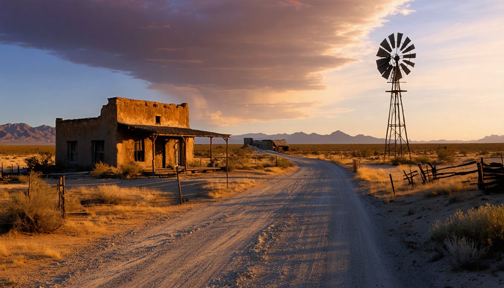
How to Get to Chispa From Van Horn
Getting to Chispa from Van Horn takes roughly one hour, but the drive demands preparation before you leave town.
Head south on Highway 90 about 30 miles, then pick up Chispa Road north of Valentine. From there, you’re committing to 56 unpaved miles through the Chihuahuan Desert.
Road conditions vary greatly with weather, so check forecasts before you roll out. Rain can turn desert dirt into an impassable mess fast.
You’ll need a rugged vehicle with solid clearance to handle the terrain crossing the Sierra Vieja Mountains.
The reward is worth it. Scenic views stretch endlessly across remote desert landscape as you descend toward the Rio Grande and Candelaria at RM 170.
Carry extra fuel, bring navigation tools, and don’t count on cell service once you’re out there.
What to Expect on Chispa Road’s 56 Miles?
Those 56 unpaved miles on Chispa Road will test both your nerves and your vehicle. You’ll cross the rugged Sierra Vieja Mountains, where the terrain shifts from open desert flats to steep, rocky descents.
The scenic landscapes here are raw and unfiltered — vast stretches of Chihuahuan Desert scrub framed by dramatic mountain ridgelines.
Keep your eyes open for local wildlife like mule deer, roadrunners, and the occasional rattlesnake crossing your path. The road demands full attention, so drive slowly and stay alert.
As you descend toward the Rio Grande, Candelaria emerges at RM 170 — a quiet, almost forgotten end point that makes every bone-rattling mile feel earned.
Bring extra fuel, water, and a reliable navigation tool. Out here, self-sufficiency isn’t optional.
Best Time of Year to Visit Chispa
Timing your visit to Chispa can make or break the experience.
Spring delivers the sweet spot — mild temperatures, spring blooms dotting the Chihuahuan Desert, and roads that haven’t baked into cracked, unforgiving hardpan. You’ll move through the Sierra Vieja Mountains without battling brutal heat or flash flood risks.
Avoid summer entirely. Triple-digit heat turns the 56-mile unpaved stretch into a dangerous gamble, and monsoon rains can wash out the road without warning.
Fall offers another solid window — cooler air, quieter skies, and exceptional stargazing nights far from city light pollution.
Winter works too, though freezing temperatures can surprise unprepared travelers.
Your best bet? Plan for March through May or September through November. The desert rewards those who respect its rhythms.
What to Pack for Chispa’s 56-Mile Dirt Road?
Before you tackle Chispa’s unforgiving 56-mile dirt road, you’ll need to pack smart or risk being stranded in one of West Texas’s most remote stretches of desert.
Toss in essential vehicle emergency supplies like a spare tire, jumper cables, and extra fuel, since there’s nowhere to refuel once you leave Van Horn.
Round out your kit with reliable navigation tools, a satellite communicator, and desert survival gear including water, sun protection, and a first aid kit, because cell service disappears fast out here.
Essential Vehicle Emergency Supplies
Tackling Chispa’s 56-mile dirt road means you’ll need to pack smart, because the remote Chihuahuan Desert won’t offer a quick rescue if something goes wrong.
Prioritize vehicle maintenance before departure — check your tire pressure, oil, and coolant levels thoroughly. Carry two full-size spare tires, a quality jack, and a tire plug kit, since sharp desert rocks can shred sidewalls without warning.
Pack jumper cables, a tow strap, and basic tools like wrenches and screwdrivers for roadside repairs. Store emergency contacts, including Culberson County Sheriff and roadside assistance numbers, in your phone and on paper.
A satellite communicator like a Garmin inReach is worth every penny out here, where cell service simply doesn’t exist and self-reliance isn’t optional — it’s survival.
Cell service vanishes almost immediately once you turn onto Chispa Road, so reliable navigation and communication tools aren’t just conveniences — they’re necessities.
Download offline navigation apps like OnX or Gaia GPS before leaving Van Horn, since you won’t have connectivity across those 56 desert miles. Freedom out here means being prepared, not stranded.
Pack these essentials before you roll out:
- Satellite communicator (Garmin inReach or SPOT) — lets you send emergency messages and share your location without cell towers
- Offline navigation apps pre-loaded with detailed topographic maps of the Sierra Vieja terrain
- Handheld GPS device as a backup to your phone
Communication devices that operate independently of cellular networks keep you connected to the outside world when the desert swallows every signal.
Desert Survival Gear
Staying connected out there keeps you safe, but communication gear alone won’t save you if the desert itself fights back.
Chispa’s 56-mile dirt road cuts through the Chihuahuan Desert, where heat, dust, and isolation demand serious preparation.
Pack more water than you think you’ll need — at least a gallon per person daily — and bring a portable water purification system for emergencies.
The desert sun is brutal, so sun protection isn’t optional. Layer on high-SPF sunscreen, wear a wide-brimmed hat, and pack UV-protective clothing.
Carry a first-aid kit, emergency blankets, a hand-operated tire pump, and basic tools.
A shovel helps if sand swallows your tires. The desert rewards the prepared and punishes the careless — don’t let freedom become a liability.
Ghost Towns You Can Reach From Chispa in a Day
Once you’ve made it to Chispa, you’re already deep in West Texas ghost town country, and a handful of fascinating historic sites sit within a day’s reach.
Ghost town exploration doesn’t get more rewarding than this stretch of the Chihuahuan Desert, where every stop carries real historical significance.
Ghost town exploration doesn’t get more rewarding than this rugged stretch of the Chihuahuan Desert.
Consider adding these destinations to your route:
- Terlingua – A former cinnabar mining hub near Big Bend featuring a cemetery, trading post, and roadside diners
- Toyah – A Reeves County railroad town that boomed in the 1880s before fading into desert silence
- Barstow – Ward County’s eeriest abandoned settlement, offering a raw, unfiltered glimpse into West Texas’s past
Each stop rewards curious travelers willing to venture off the beaten path.
Frequently Asked Questions
Is There Cell Phone Service Available Along Chispa Road’s Remote Route?
Don’t count on cell coverage along Chispa Road’s 56 miles of rugged terrain. In these remote areas, you’re truly off the grid, so download maps, inform someone of your route, and embrace the wild freedom!
Are Guided Tours Available for Visiting Chispa and Surrounding Ghost Towns?
Imagine joining a seasoned desert guide sharing Terlingua’s eerie local legends around a campfire — you’ll find guided explorations are available through local operators, letting you uncover Chispa’s haunting West Texas history firsthand.
Can Visitors Legally Cross Into Mexico Near Candelaria at RM 170?
You can’t easily make a legal border crossing near Candelaria at RM 170, as it lacks an official port of entry. Always check current legal requirements before attempting any international travel in this remote area.
What Is the Historical Significance of Chispa’s Original Railroad Settlement?
Chispa’s WiFi-free roots run deep — you’re standing where railroad expansion forever shaped West Texas in the late 1800s. Its settlement impact fueled mining operations, connecting remote desert communities and transforming the region’s economic and cultural landscape.
Are There Any Overnight Camping Options Near Chispa or Candelaria?
You’ll find primitive camping options near Candelaria, where you can sleep under vast desert skies with minimal camping amenities. Embrace the freedom of the Chihuahuan Desert, but watch for local wildlife roaming these rugged, untamed lands nightly.
References
- https://www.texasescapes.com/TexasGhostTowns/ChispaTexas.htm
- https://www.youtube.com/watch?v=ZMagOUMAq8Y
- https://www.youtube.com/watch?v=9k-Yo7LUxnY
- https://valentinetexas.wordpress.com/2010/10/31/chispa-road-video/
- https://dallasexpress.com/state/road-trip-across-texas-explore-13-of-the-spookiest-ghost-towns/
- https://texashighways.com/culture/history/what-the-heck-is-a-ghost-town/
- https://www.texasescapes.com/Texas-Ghost-Towns-A-to-Z.htm
- https://www.huffpost.com/entry/abandoned-america-night_n_4079720
- https://www.youtube.com/watch?v=uyNGzid-cxs
- https://texasghosttours.com/2025/04/22/haunted-highways/


