Hagerman, Texas sits 80 miles north of Dallas, submerged beneath Lake Texoma since Denison Dam’s gates closed in 1943. When drought drops water levels, sunken foundations, street outlines, and ghostly remnants resurface along the Big Mineral arm. You’ll want to check current lake elevations before visiting, wear sturdy footwear, and target Hagerman National Wildlife Refuge as your navigation point. Stick around, because there’s much more to uncover about this forgotten farming town‘s fascinating story.
Key Takeaways
- Hagerman, Texas, a town submerged beneath Lake Texoma in 1943-1944, resurfaces during drought years, revealing foundations and street outlines along the Big Mineral arm.
- Drive approximately 80 miles north of Dallas into Grayson County, following signs from U.S. Highway 75 toward Hagerman National Wildlife Refuge.
- Check U.S. Army Corps of Engineers lake elevation data before visiting to maximize visibility of submerged ruins during low water levels.
- Wear appropriate footwear, download a historical map, and plan your visit around water levels for the best ghost town exploration experience.
- Visit the relocated cemetery year-round to see founder J.P. Smith’s grave, and explore church remnants 2-3 miles southeast of the original townsite.
The Forgotten Farming Town Now Beneath Lake Texoma
Beneath the murky waters of Lake Texoma lies a forgotten farming town that once bustled with cotton gins, church bells, and the rumble of Missouri-Kansas-Texas Railroad trains. Hagerman, Texas, tells a story of forgotten history that most people never get to uncover.
Settled in the early 1870s, roughly 80 miles north of Dallas, this tight-knit community grew to 250 residents by 1910. Three churches, a three-teacher school, and a thriving depot defined its peak.
Then Lake Texoma’s creation changed everything. Between 1943 and 1944, the completed Denison Dam swallowed Hagerman whole, burying its submerged secrets beneath 83,000 acres of water.
When lake levels drop, remnants of this ghost town resurface, offering you a rare glimpse into a world that water couldn’t entirely erase.
How Hagerman, Texas Was Swallowed by the Lake in 1943
When the Denison Dam’s gates closed in 1943, water crept steadily over Hagerman’s cotton fields, swallowing its depot, churches, and homes one by one.
When Denison Dam’s gates closed in 1943, rising waters swallowed Hagerman’s fields, churches, and homes forever.
What had thrived as a close-knit farming community since the 1870s simply vanished beneath what became Lake Texoma’s 83,000-plus acres.
Residents didn’t leave quietly. The Morrison family documented their farewell through heartfelt photos and video, preserving community memories that still circulate online today.
Families packed their lives and relocated, watching lake history erase everything they’d built across generations.
When Lake Texoma Drops Low Enough to Reveal It
Drought years work in curious ways for history buffs—Lake Texoma’s water levels occasionally drop low enough to expose the ghostly remnants of Hagerman’s submerged history along the Big Mineral arm.
When lake exposure happens, you’ll spot foundations, outlines of streets, and structural debris that haven’t seen daylight in decades. These windows into the past don’t follow a schedule, so you’ll want to monitor the lake’s water levels before making the drive up from Dallas.
The U.S. Army Corps of Engineers publishes current lake elevation data online, giving you the intel you need to time your visit right.
When conditions align, standing at the water’s edge and peering into Hagerman’s drowned streets delivers a raw, unscripted encounter with Texas history you simply can’t manufacture elsewhere.
How to Reach Hagerman’s Submerged Site on the Big Mineral Arm
Getting to Hagerman’s submerged site takes a bit of navigational intent, but the route is straightforward once you know where you’re headed. Drive approximately 80 miles north of Dallas into Grayson County, targeting the Hagerman National Wildlife Refuge as your anchor point.
Reaching Hagerman’s sunken history requires purpose, but the path north of Dallas into Grayson County is refreshingly uncomplicated.
The refuge has served visitors since 1946 and sits directly along the Big Mineral arm of Lake Texoma, where the old townsite rests beneath the surface.
For access routes, follow the signs toward the refuge off U.S. Highway 75, then navigate the refuge roads toward the shoreline.
Visitor tips worth remembering: check Lake Texoma water levels before you go, since low water dramatically improves what you’ll see. Bring binoculars, wear water-appropriate footwear, and download a historical map to orient yourself on the exposed lakebed.
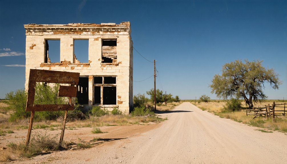
What Survives: Sunken Foundations, a Relocated Cemetery, and the Church Above Water
Once you’ve made your way to the shoreline, the real question becomes: what’s actually left of Hagerman? Surprisingly, more than you’d expect. When lake levels drop, sunken foundations emerge from the water, giving you a rare glimpse into streets and structures that haven’t seen daylight in decades.
The historical significance of these moments isn’t lost on visitors who stand where farmers once walked.
Above the waterline, you’ll find church remnants still standing 2-3 miles southeast — a modest metal building marking where community once gathered.
The relocated cemetery sits several miles from the original townsite, where founder J.P. Smith’s grave remains accessible year-round. Together, these surviving pieces connect you directly to a town that didn’t fade away — it was deliberately swallowed whole by Lake Texoma.
Frequently Asked Questions
Are There Guided Tours Specifically Focused on Hagerman’s Submerged History?
You won’t find official guided tours focusing on Hagerman’s submerged history, but you can explore its ghost town legends independently through Hagerman Wildlife Refuge, scuba diving over sunken remnants, or researching fascinating 1943 farewell photos documenting this underwater world.
What Is the Best Time of Year to Visit Hagerman Wildlife Refuge?
Hark, you’ll find winter’s your prime season! Migratory waterfowl flood the refuge, exploding your birdwatching opportunities and wildlife photography game. You’ll spot thousands of geese and ducks painting the sky spectacularly between November and February.
Do You Need a Permit to Scuba Dive Over the Submerged Town?
You’ll want to check current scuba regulations with local authorities before diving over Hagerman’s submerged streets. Diving safety rules may apply, so contacting the Army Corps of Engineers guarantees you’re exploring freely and legally.
Are There Nearby Hotels or Campgrounds for Overnight Ghost Town Visitors?
You’ll find great camping options at Hagerman Wildlife Refuge and nearby Lake Texoma State Park. For hotel recommendations, Sherman’s local accommodations are just miles away, giving you the freedom to explore this fascinating submerged ghost town fully!
Can Visitors Access Historical Morrison Family Farewell Photos at a Local Museum?
Exploring historical significance and honoring family legacy, you’ll find the Morrison farewell photos and videos from 1943 available online rather than at a local museum, letting you freely discover Hagerman’s poignant, documented final moments anywhere.
References
- https://www.texasescapes.com/CentralTexasTownsNorth/Hagerman-Texas.htm
- https://texashighways.com/travel-news/four-texas-ghost-towns/
- https://www.redriverhistorian.com/post/basin-springs-steedman-hagerman-cedar-mills-lake-texoma
- https://www.405magazine.com/uncovering-lake-texomas-submerged-ghost-towns/
- https://www.youtube.com/watch?v=SUEbfP6hLLM
- https://www.tshaonline.org/handbook/entries/hagerman-tx


