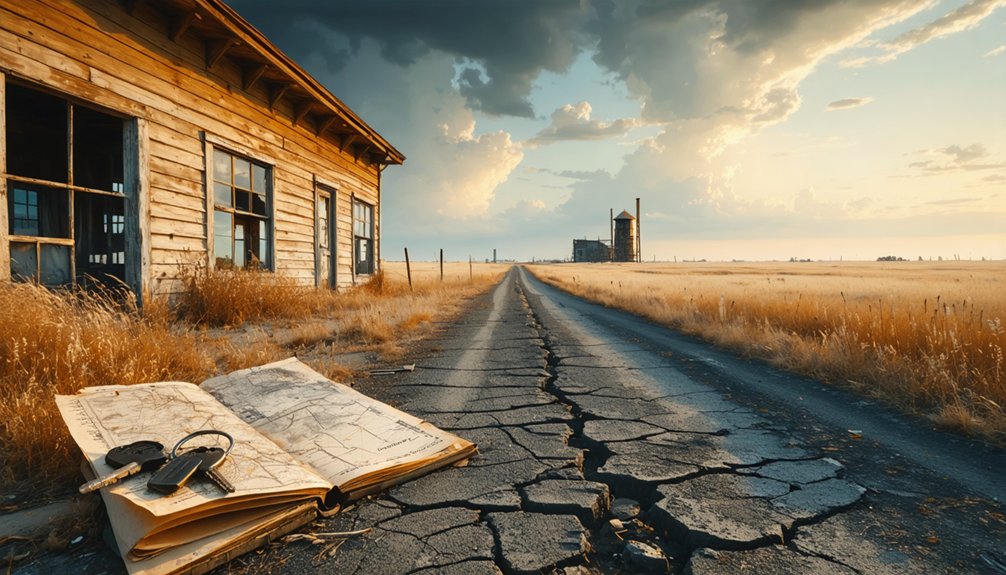
To plan your ghost town road trip to Medora, Kansas, start in Hutchinson and head west on US Highway 50 before branching onto rural county roads. Medora once thrived where the Rock Island and Frisco railroads crossed, but today it’s reclaimed prairie with crumbling foundations and rusted track remnants. Visit in spring or early fall for the best conditions. Pack water, offline maps, and a spare tire — there’s much more to uncover ahead.
Key Takeaways
- Medora, Kansas, was once a railroad junction town whose remnants include rusted tracks, crumbling foundations, and overgrown lots reclaimed by prairie grasses.
- From Hutchinson, head west on US Highway 50, then branch onto Reno County roads, using offline maps due to unreliable rural GPS signals.
- Visit during spring or early fall for mild temperatures, better road conditions, and ideal golden-hour photography of abandoned structures.
- Pack emergency essentials including water, a spare tire, jumper cables, offline maps, and layered clothing for unpredictable Kansas weather conditions.
- Extend your trip by visiting nearby ghost towns like Arvonia, Drury, and Donovan, using US Highway 50 as your main travel corridor.
What Made Medora, Kansas a Ghost Town?
Once a bustling railroad junction in Reno County, Medora thrived because two major lines — the Chicago and Rock Island Railroad and the St. Louis and San Francisco Railroad — crossed right through it.
That railroad impact turned Medora into a crucial freight and passenger hub during the late 19th century, drawing settlers and commerce to what had been open Kansas prairie.
Railroads transformed empty Kansas prairie into a thriving hub, pulling settlers and commerce into Medora’s growing orbit.
Medora history tells a familiar story, though. As railroads lost their dominance and transportation shifted, the town’s purpose evaporated.
The post office, which had operated since 1887, finally closed in 1988 — fundamentally marking Medora’s official end. No businesses survived. No residents stayed.
What you’ll find today are faint remnants and open land, a quiet reminder of how quickly a community disappears when its economic foundation collapses.
How to Get to Medora From Hutchinson
If you’re starting your ghost town adventure in Hutchinson, head west on US Highway 50, which serves as your main corridor into Reno County’s rural stretches.
You’ll eventually shift from paved highways onto county roads that cut through flat farmland, bringing you closer to Medora’s forgotten junction.
For the final approach, expect dirt roads that demand a reliable vehicle and a good map, since GPS often loses its reliability in Kansas’s more remote corners.
Starting Point In Hutchinson
Hutchinson serves as your ideal launching pad for the roughly 20-mile drive southwest to Medora, placing you squarely in the heart of Reno County’s forgotten railroad country.
You’ll find Hutchinson well-equipped with fuel stations, restaurants, and supply stops before you head into open terrain where conveniences disappear fast.
From downtown Hutchinson, take US Highway 50 west, then navigate south using county roads toward Medora’s former townsite. You’re fundamentally retracing routes that once connected thriving communities built entirely around railroad significance.
Medora’s ghost town history stretches back to 1887, when dual rail lines made it a genuine transportation hub worth settling near.
Pack water, download offline maps, and check road conditions beforehand. Those final county roads turn to dirt quickly, and you’ll want zero surprises once civilization fades behind you.
Key Roads And Highways
Three key roads connect Hutchinson to Medora’s ghost town site, and knowing them in advance saves you from second-guessing every unmarked intersection along the way.
Head out using this straightforward route:
- US Highway 50 – Your primary westward corridor leaving Hutchinson
- Reno County Road – Branches south toward Medora’s rural exploration zone
- Unmarked dirt roads – Final approach requiring a reliable atlas or GPS
- Railroad remnant paths – Overgrown tracks occasionally guide navigation near the site
You’re chasing ghost town history here, so expect minimal signage. The landscape shifts from small-town Kansas into open farmland quickly.
Keep your DeLorme Atlas handy, watch for county road markers, and trust your instincts. Medora doesn’t advertise itself — that’s exactly what makes finding it rewarding.
Final Approach Via County Roads
The final stretch from Hutchinson to Medora demands attention once you leave US Highway 50 behind. Your final approach shifts from smooth pavement to winding county roads cutting through central Reno County’s open landscape.
Expect dirt or gravel surfaces that reward drivers who come prepared with a reliable vehicle and a printed map or downloaded offline GPS route.
You’ll navigate intersecting county roads where signage grows sparse, so tracking your coordinates matters. The DeLorme Kansas Atlas remains a trusted companion here, giving you grid-level detail that phone apps often miss in rural areas.
Watch for unmarked turnoffs and slow down near railroad remnants scattered along the roadside. Medora won’t announce itself grandly — you’ll simply arrive at quiet, empty land that once hummed with railroad life.
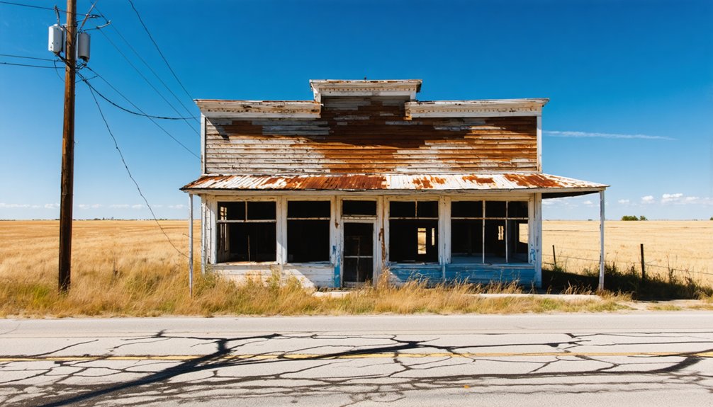
What Remains at Medora’s Townsite Today
Although Medora’s post office finally shuttered in 1988, the townsite itself has faded into something far more ghostly than a mere closure suggests.
You’ll find a landscape stripped of its former energy, yet rich with historical significance and whispered local legends. Here’s what you can expect to encounter:
- Faded railroad remnants where dual lines once intersected
- Crumbling foundations marking former businesses and homes
- Overgrown lots reclaimed by central Kansas prairie grasses
- Scattered debris hinting at the town’s railroad junction origins
Walk the site freely and let the silence speak.
There’s no admission gate, no guided tour — just raw, unfiltered history beneath your boots.
Medora doesn’t demand anything from you except your curiosity and respect for what once thrived here.
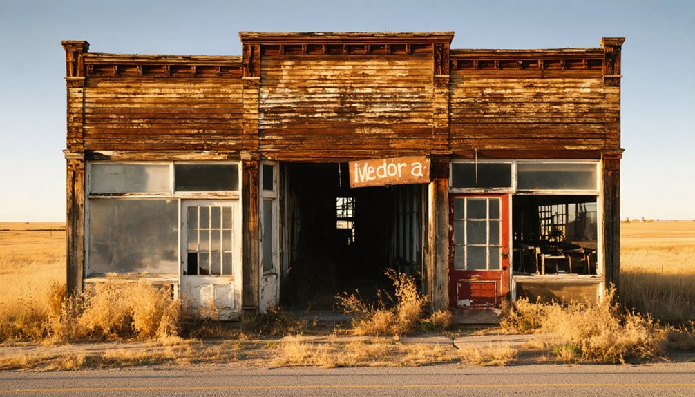
Railroad Ruins and Structures Still Visible at Medora
As you walk Medora’s townsite, you’ll notice rusted track remnants cutting through the overgrown landscape, silent evidence of the two railroad lines that once defined this junction.
The abandoned infrastructure where the Chicago and Rock Island crossed the St. Louis and San Francisco Railroad still hints at the operational complexity this small Kansas settlement once supported.
You can trace the ghost of the rail corridors through subtle grade changes in the earth, weathered tie fragments, and scattered hardware half-buried in the soil.
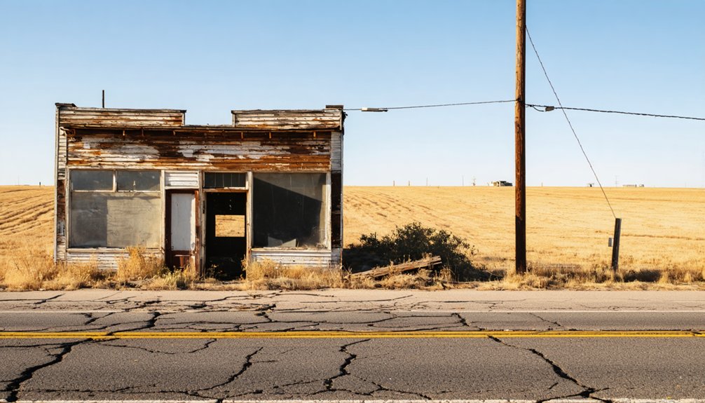
Visible Railroad Track Remnants
Rusted rail lines and weathered crossties still cut across the Kansas prairie at Medora, offering ghost town explorers a rare, tangible connection to the town’s railroad past.
This transportation legacy shaped everything Medora once was, and you can still read that railroad history in the landscape today.
Watch for these remnants as you explore:
- Rusted iron rails partially buried in overgrown prairie grass
- Rotting wooden crossties scattered along former track corridors
- Graded earthen berms marking original rail bed alignments
- Junction fragments where Chicago, Rock Island and Frisco lines once crossed
Walk the old corridors carefully and you’ll feel the ghost of commerce beneath your boots.
These fragments don’t just mark where trains ran — they mark where a community’s entire existence once depended.
Abandoned Junction Infrastructure
Beyond the rails and crossties themselves, three core junction structures still haunt the Medora site: switching mechanisms, signal post foundations, and platform remnants where freight once changed hands between the Chicago and Rock Island and Frisco lines.
You’ll notice the abandoned infrastructure embedded in overgrown soil, each piece carrying genuine historical significance as evidence of a once-active Kansas railroad hub. Rusted switch levers sit frozen mid-operation, as if workers simply walked away mid-shift.
Signal post bases jut from the earth like concrete stumps, marking where communication once coordinated two major rail corridors. The loading platform edges, though crumbled, still outline where commerce moved.
Bring a camera and sturdy boots—you’re walking through a functional industrial ghost, and every corroded bolt tells part of Medora’s forgotten story.
When Is the Best Time to Visit Reno County Ghost Towns?
When you plan your ghost town road trip to Medora and Reno County’s other lost communities, timing can make or break the experience.
Best seasons and weather considerations matter enormously on rural Kansas dirt roads.
- Spring (April–May): Mild temperatures and green landscapes enhance photography, though rain softens dirt roads.
- Early Fall (September–October): Cooler air and golden light create dramatic ghost town atmosphere without summer’s brutal heat.
- Summer (June–August): Long daylight hours maximize exploration time, but Kansas heat exceeds 100°F regularly.
- Winter (December–February): Sparse crowds offer solitude, but icy county roads can trap your vehicle miles from help.
Pack water, download offline maps, and always check Reno County road conditions before heading out toward Medora’s forgotten junction.
Which Ghost Towns Should You Add Near Reno County?
Extending your Reno County ghost town road trip into neighboring areas reveals a richer collection of forgotten Kansas communities worth your time.
Chautauqua County’s Peru offers a living example of a fading town, with just 101 residents and a median age of 62, making it a compelling stop for ghost town exploration.
Peru, Kansas: 101 residents, median age 62 — a town fading in real time before your eyes.
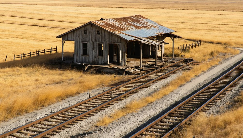
Drury draws you in with weathered buildings standing near abandoned railroad tracks, while Donovan challenges you with dirt road access that rewards persistent explorers.
For deeper historical significance, Arvonia delivers a fascinating railroad and limestone quarry legacy.
Greenwood County’s oil boom remnants scattered across multiple lost communities round out your journey beautifully.
Each destination adds distinct character, ensuring your road trip captures Kansas’s layered, forgotten past beyond Reno County’s borders.
What to Pack for a Rural Kansas Ghost Town Drive
Packing smart makes the difference between a memorable ghost town drive and a frustrating one. Rural Reno County roads don’t forgive poor preparation, so load up deliberately before heading toward Medora.
Your packing essentials should cover these four priorities:
- Navigation tools – Download offline maps since cell service disappears fast on county dirt roads.
- Ghost town photography gear – Bring a wide-angle lens, extra batteries, and a tripod for capturing crumbling railroad remnants in low light.
- Emergency supplies – Pack water, a spare tire, jumper cables, and a first-aid kit.
- Weather protection – Kansas weather shifts quickly, so layer clothing and carry rain gear.
You’re exploring abandoned places on your own terms, so equip yourself to stay independent, comfortable, and ready for whatever the road delivers.
How to Build a Road Trip Using Medora as Your Central Kansas Base
Medora sits at the heart of central Kansas like a forgotten crossroads, making it a natural anchor point for a multi-stop ghost town circuit. Start your loop here, absorbing the railroad history embedded in the landscape where two major lines once intersected.
From Medora, push east toward Arvonia for limestone quarry ruins, then swing toward Drury’s weathered buildings for compelling ghost town photography opportunities.
Head south to explore Greenwood County’s oil boom remnants before looping back through Peru, a fading community that still breathes faintly.
Use US Highway 50 as your backbone corridor, branching off onto county roads as needed. Keep your camera ready — the light shifts dramatically across the Kansas plains, turning every crumbling structure into something worth documenting.
Frequently Asked Questions
Is There an Entrance Fee or Permit Required to Visit Medora?
You don’t need to worry about entrance requirements or permit details when visiting Medora! It’s freely accessible via rural Reno County roads, so you can explore this hauntingly abandoned railroad ghost town without any restrictions holding you back.
Are Overnight Camping Options Available Near the Medora Townsite?
You won’t find a single campsite for miles around Medora’s ghostly ruins! You’ll need to seek camping amenities in nearby Hutchinson, where you can also spot local wildlife before exploring this forgotten Kansas treasure.
You’ll likely find Medora on GPS apps, though it’s minimally marked. Search Reno County rural roads to uncover this ghost town’s Medora history and hidden ghost town attractions waiting to reward your adventurous, freedom-seeking spirit!
Is the Medora Site Privately Owned or on Public Land?
The knowledge doesn’t confirm Medora’s exact land ownership, so you’ll want to research that before visiting. Respecting Medora history means honoring ghost town preservation by checking local Reno County records to guarantee you’re accessing the site legally.
Are There Guided Tours Available for Reno County Ghost Towns?
Like ancient town criers spreading news, you won’t find formal guided tours, but you can explore Reno County’s ghost town history independently, uncovering local legends through self-guided adventures, historical indexes, and John Wise’s documentary video channel.
References
- https://www.youtube.com/watch?v=Aa-_f4ThouQ
- https://www.youtube.com/watch?v=YQHVP21sYC8
- https://www.youtube.com/watch?v=KBXINX0xqnU
- https://www.onlyinyourstate.com/trip-ideas/kansas/kansas-ghost-town-road-trip
- https://www.travelks.com/kansas-magazine/articles/post/exploring-kansas-forgotten-roads/
- https://legendsofkansas.com/everyplace-in-kansas-m/


